Scenic Byway 12
At least 28 places or things to see and do.
The Ultimate Insider's Guide To Scenic Byway 12
Author: Mark WadeUtah's Scenic Byway 12 is featured by the United States federal government as an All American Road, and has been rated by multiple media sources as one of the Top Scenic Drives in America. It may rank as one of the world's most scenic roads or highways. The subsequent text, photos, and videos provide some of the answers to commonly asked questions such as;
- Is Scenic Byway 12 worth it?
- Where does Scenic Byway 12 start and end?
- What to see on highway 12 in Utah?

Where is Scenic Byway 12?
This road was not fully paved until 1975 and stretches across a significant area within central part of southern Utah. From Torrey (north end) to the Junction of Highway 89 (southern end), Scenic Byway 12 leads through a beautiful and varied landscape of red rock formations, cliffs, deep slot canyons, high timbered plateaus, and lush alpine forests, and at elevations ranging from 5,000 to over 9,000 feet. The byway winds through an outdoor paradise for hiking, mountain biking, horseback riding, camping, fishing, and some excellent areas for rock climbing or rappelling (canyoneering). Along this route travelers have access to two national parks, three state parks, a national forest, a national monument, and numerous other world-class scenic attractions. See more text information, photos, videos, and maps below.

Where does Scenic Byway 12 start and end?
This highway connects with Highway 89 on the southwestern end, and passes through Bryce Canyon National Park as it winds to the north in a horseshoe fashion toward Highway 14 near Capitol Reef National Park.
How Long is Scenic Byway 12?
This scenic route is 124 miles (199 KM) in length, and ranges in elevation from approximately 5,500' (1767m) to over 9,000' (2,743m).
How Long to Drive Scenic Byway 12?
Under regular traffic and weather conditions, and with no stops, the drive takes approximately 2 hours and 45 minutes from end to end. This route is very much worth the drive, even if you don't stop, but of course there are plenty of reason to stop and stretch your legs, stand at scenic overlooks to take in the views, take photos, go walking or hiking, and we suggest that Scenic Byway 12 can be a week-long vacation in and of itself.
What to see on Scenic Byway 12 - Utah?
The list of options of what to see and do on this scenic road is lengthy. We'll start at the southwest end of the road and take you to the northern end.
Please note that Panguitch, Utah and Hatch, Utah are not on the byway itself, but both are within 10 miles of the southwest beginning point of this route, and also both offer lodging, dining, and shopping services. Please note that winter-time services may be more limited.
Please note that Panguitch, Utah and Hatch, Utah are not on the byway itself, but both are within 10 miles of the southwest beginning point of this route, and also both offer lodging, dining, and shopping services. Please note that winter-time services may be more limited.
1- Losee Canyon and Casto Canyon
From the junction of Highway 89, and just prior to entering the Red Canyon area on Scenic Byway 12, there is a dirt road that turns north and leads a short distance to the trail heads of Losee Canyon and Casto Canyon. These are lesser known areas that offer stunning views of formations similar to that seen in Red Canyon or Bryce Canyon. These canyons are sometimes frequented by ATV riders, or via horseback, but are open for hiking.

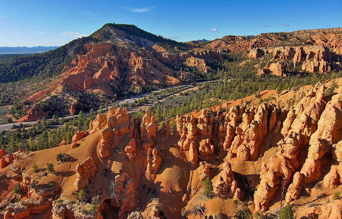
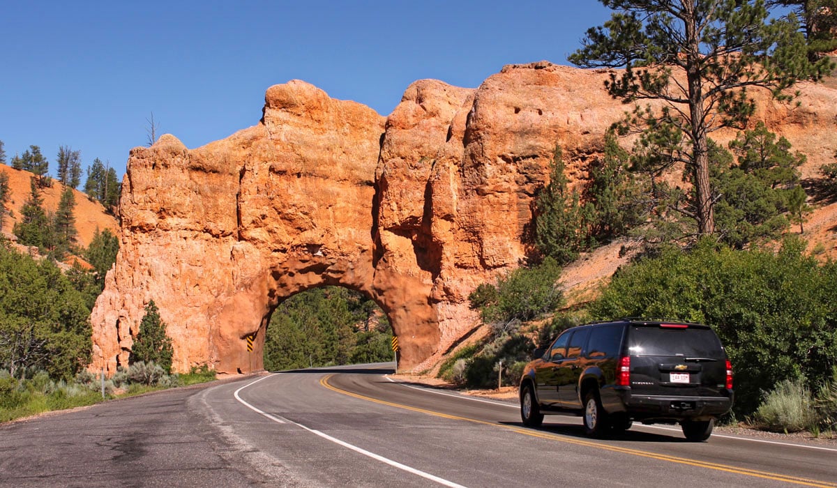
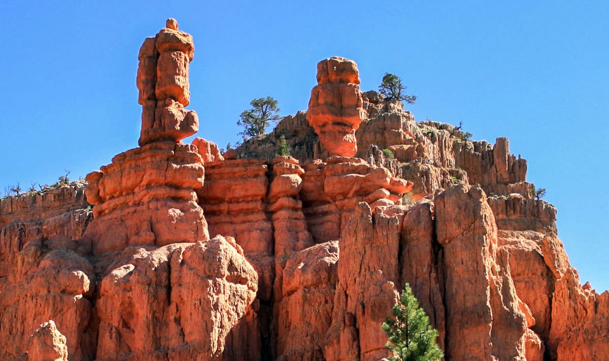
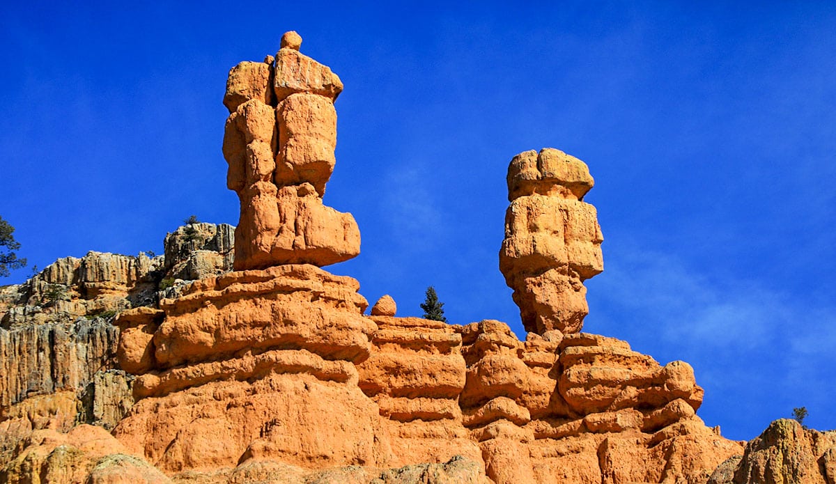
2- Red Canyon
From the junction of Highway 89 and Scenic Byway 12, Red Canyon is just two miles to the east and is a place to catch a glimpse of what Bryce Canyon National Park also looks like. Nestled within the edge of the Dixie National Forest, you'll be standing at the base of beautiful limestone formations and looking up at them, rather than down as is most common at Bryce Canyon National Park. There's a seasonally open Visitor Center here, along with short hiking trails among the hoodoo formations, and there is also a paved path that extends through Red Canyon that is ideal for walking, blading, cycling or mountain biking.
3- Thunder Mountain Trail
This is a dirt path or single-track trail with trailhead access at the top and bottom of Red Canyon and is ideal for mountain biking. Some enjoy starting at the top and zooming down the trail, while others prefer the challenge of a mountain bike climb up the paved path and the fast descent on the Thunder Mountain single-track.

4- Bryce Canyon National Park:
This is one of the two national parks found along Scenic Byway 12, and is an attraction that is sought by people from around the world. Bryce Canyon is named for Ebenezer Bryce who was an early settler and rancher in the valley to the east of Bryce Canyon. Turn to the south on Highway 63 and travel about three miles, past historic Ruby's Inn, to the gate of Bryce Canyon National Park. Learn more about Bryce Canyon

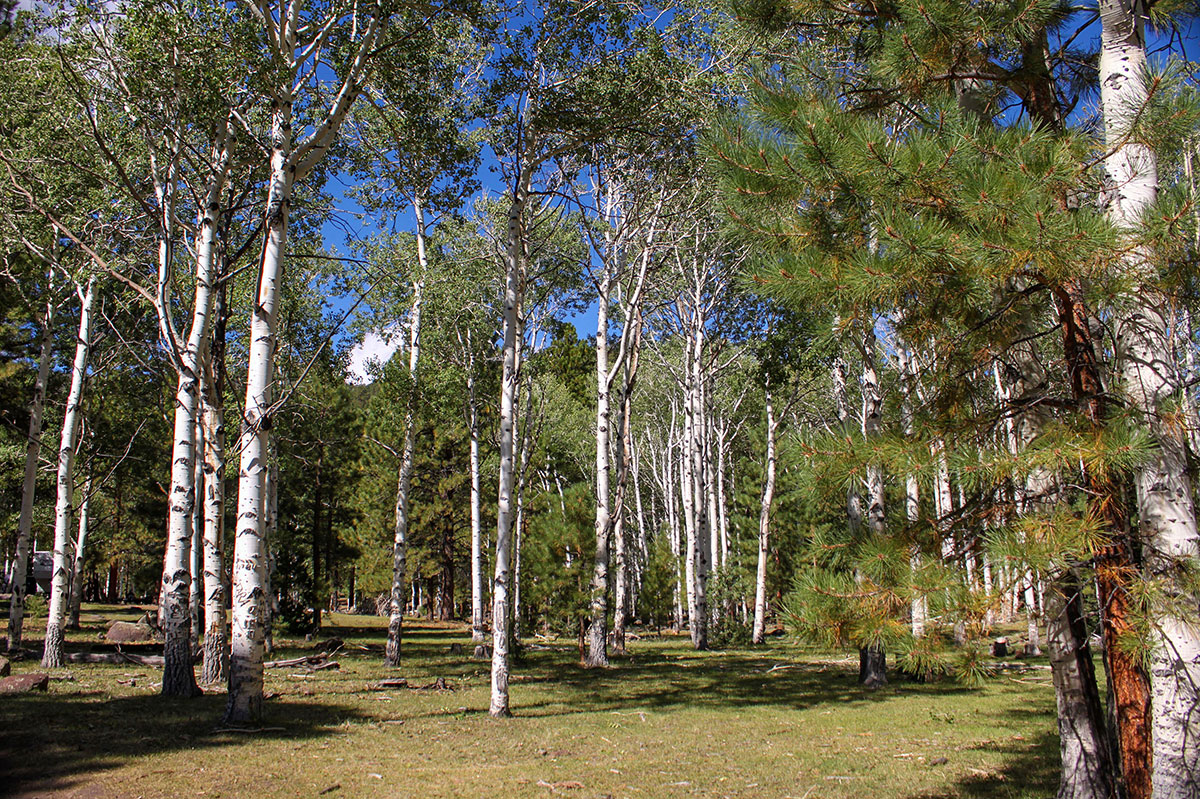
5- Dixie National Forest
Two sections of the Dixie National Forest in southwestern Utah encompass the area around Bryce Canyon and also the Boulder Mountain plateau, both of which are accessible from Byway 12. Elevations for the forest range from approximately 6,500' to over 11,000'.
6- Mossy Cave
Two sections of the Dixie National Forest in southwestern Utah encompass the area around Bryce Canyon and also the Boulder Mountain plateau, both of which are accessible from Byway 12. Elevations for the forest range from approximately 6,500' to over As you descend from the Bryce Canyon plateau toward the town of Tropic, Utah, you'll come across a section of Scenic Byway 12 that passes through Bryce Canyon National Park. Here you find a hiking trail that crosses a wash with water flowing from an area called Mossy Cave, where there is a small waterfall and a cave-like rock overhang environment that thrives on the moisture from the water passing through. Even in winter, this can be an enjoyable view as the cave area moisture freezes to create a surreal menagerie of ice. At certain times of year water is diverted into this area through what has been created by early pioneers and is known as the Tropic Ditch, and this also can create a visible waterfall.
11,000'.
11,000'.

7- Tropic, Utah
This small town sits just below Bryce Canyon and is visible from various overlooks within the national park. Tropic acquired its name from the somewhat wishful thinking of an early resident who hoped to grow tropical fruits in the area. Here you'll find visitor services such as lodging, dining, grocery store, and gifts.

8- Cannonville, Utah
Just a couple of miles further along Highway 12 is the scenically positioned community of Cannonville. Here you'll find a Visitor Center for the Grand Staircase Escalante National Monument and access roads that lead to Kodachrome Basin State Park and to slot canyons such as Willis Creek Slot Canyon.

9- Willis Creek Slot Canyon
This very interesting slot canyon is accessible from a dirt road that breaks south from the paved road that leads to Kodachrome Basin State Park. Access to Willis Creek slot canyon begins right off the road. Be aware that dirt roads and slot canyons should only be accessed during good weather conditions.

10- Kodachrome Basin State Park
Just seven miles southeast of Cannonville, Utah is Kodachrome Basin State Park (paved road all the way). Many of the towering monolithic spires in this state park began to form when ancient geysers ceased functioning. The vertical holes in the surrounding terrain, left by the geysers, were subsequently filled with a different type of sediment which then hardened into solid rock. Eventually the softer surrounding sediment was eroded away, leaving the hardened towers still standing, and that is the magic of what is seen today in Kodachrome Basin. The area's name comes from the once famous Kodachrome photography film created by the Kodak company.

11- Grosvenor Arch
For those willing to venture down a dirt road for an additional 11 miles past Kodachrome Basin, you'll be rewarded with views of majestic Grosvenor Arch. Return past Kodachrome to continue on Scenic Byway 12.

12- The Blues Wayside / Powell Point Vista
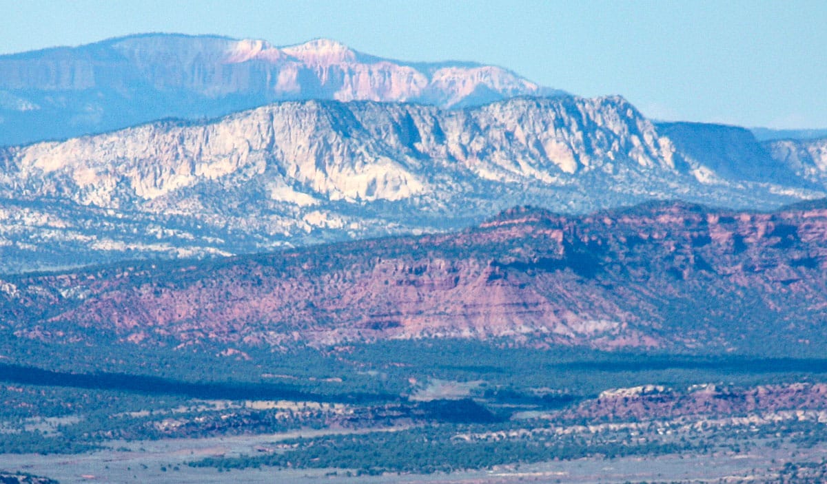
From Cannonville, Scenic Byway 12 passes through the small pastoral farming community of Henrieville Utah, and then begins to ascend to the benches of the Aquarius Plateau or what is known as Boulder Mountain. At the roads highest point, in this area, there is a pull-out where travelers can enjoy the views of what is know as The Blues. These are grey-blue colored formations that are somewhat similar to what is seen in Bryce Canyon but without the same iron-stained coloration of the limestone found within the national park. Above The Blues is the majestic southwest end of Boulder Mountain and the formations referred to as Powell Point and named for the famous explorer of the Colorado River, John Wesley Powell.

13- Boulder Mountain
This mountain is actually a plateau, and is said to be the highest forested plateau in North America with 80 lakes scattered across Boulder Mountain. It is said that this mountain was once called Thousand Lakes Mountain until a map-maker (cartographer) mistakenly labelled it Boulder Mountain, and the accidental name change eventually became its common name. Access to this mountain is via multiple dirt roads that connect to Byway 12.

14- Upper Valley Granaries
Just off the highway is a vehicle pull-out with metal cylinder viewing tubes that point to some ancient grain storage rock huts situated about 50' above the road in a cliff-face. Access to such sites was purposely difficult so food could be safely stored.

15- Escalante Petrified Forest State Park
Just off the highway you'll find access to view ancient petrified trees along a slightly elevated hiking trail within this state park. There is also a reservoir for swimming, kayaking, paddleboarding, and fishing at this small lake near the town of Escalante, Utah.

16- Escalante, Utah
At an elevation of 5,820' this community is a great place from which to hub-and-spoke to explore the many attractions along, and surrounding, Scenic Byway 12. Settled in 1875 by pioneers who were members of the Church of Jesus Christ of Latter Day Saints (nicknamed Mormons), the town's name comes from Silvestre Velez de Escalante, a Spanish explorer who ventured through the region in 1776.
The Escalante Heritage Center
at the northeast end of town provided great insights to the epic Hole-in-the-Rock expedition which used Escalante as a gathering point for the approximately 250 men, women, and children participants. Escalante now offers year-round lodging, dining, groceries, gift, fuel, and other visitor services. From the area around Escalante there are multiple dirt-road routes that lead up on to Boulder Mountain to access its many lakes for fishing, camping, and exploreation in the Dixie National Forest.

17- The Escalante River
The Escalante River is formed by two Boulder Mountain creeks that come together near Escalante, Utah and then funnels down through the Grand Staircase for 90 miles toward the Colorado River or what is now known as Lake Powell, within the Glen Canyon National Recreation Area. The Escalante River is generally a shallow and relatively narrow waterway except during large rainstorms or during spring runoff caused by snow melting on Boulder Mountain.

18- The Grand Staircase-Escalante National Monument
Visitors love to explore this vast wilderness of slot canyons and dramatic geological formations of this large national monument. The best access into the Grand Staircase-Escalante National Monument is via the famous Hole In The Rock Road which was developed by the early pioneers on the Hole-In-The-Rock expedition.

19- The Hole In The Rock Road
As you drive down this dirt road you'll find numerous slot canyons on your left (northeast) and formations such as the Kaiparowitz Plateau, and Devils Garden (Metate Arch) on your right (southwest). Slot canyons such as Egypt slot, Peekaboo slot and Spooky slot, Zebra slot, and other attrctions such as Dance Hall Rock, and Coyote Gulch are all found along the way to the actual Hole In The Rock at the rim of the Colorado River, which is part of Lake Powell (Glen Canyon NRA).

20- Head of the Rocks Overlook
From Escalante you'll travel east to the Head of the Rock overlook where, from a road-side pullout, you'll gaze across much of the vast expanse of the Grand Staircase. From here you'll begin to appreciate how incredible it was to create a paved road in, over, and around this maze of canyons.

21- Lower Calf Creek Falls
Calf Creek feeds into the Escalante River, but before it arrives there it carves its way over and through sandstone formations and at one point it cascades over a beautiful 126-foot cliff in a waterfall that crashes to a pool below. The creek then flows along a very popular and scenic hiking trail, approximately 2.5 miles in length. Along this water course hikers are treated to views of the creek and even some large pictographs on the far canyon walls.

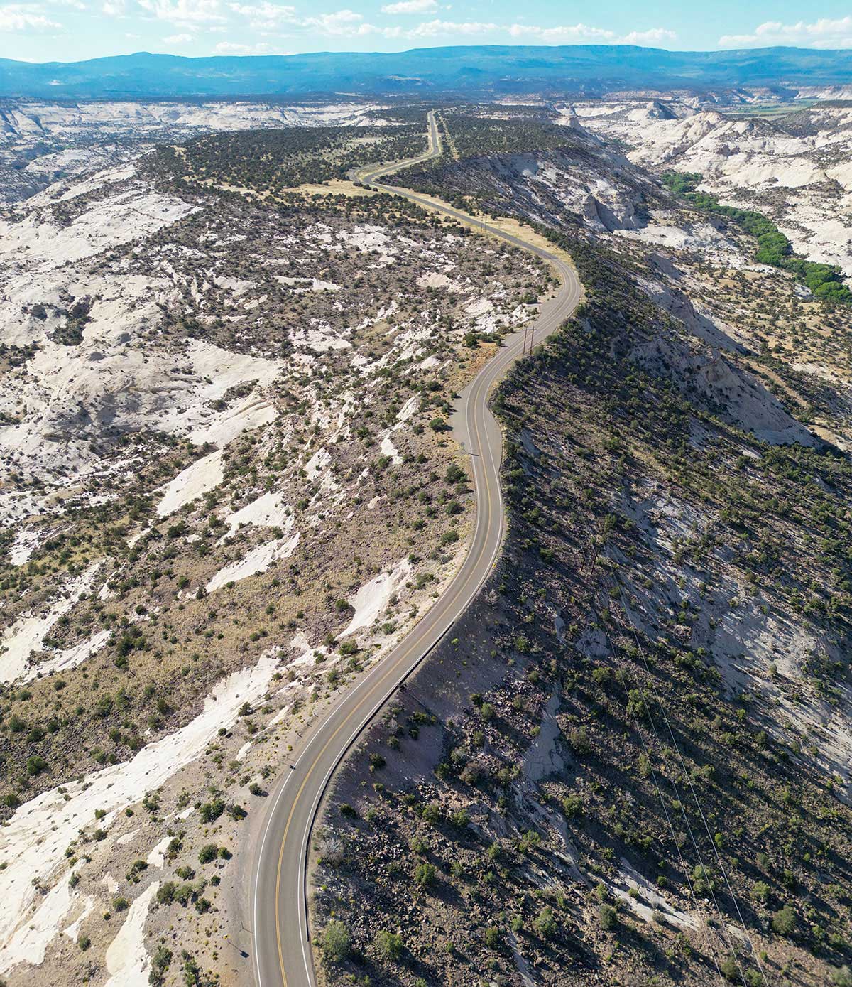
22- The Hogback
Between Upper and Lower Calf Creek Falls is a section of the byway that is referred to as The Hogback, perhaps for the manner in which the formations on either side of the road roll-off many hundreds of feet to canyons or gorges below. In spots the road literally follows the spine of a rock formation and the descent is quite steep on both sides of the road.
23- Upper Calf Creek Falls
Further up (north) along Scenic Byway 12 is the upper falls of Calf Creek. There is a one-mile steep descent down a rough sandstone route to get to these falls. Remember that you'll need to return uphill the way you came, and this difficult ascent should be considered when choosing to hike down to these falls.

24- Hell's Backbone Bridge
This bridge and the Hell's Backbone Road - 38 miles in length, were built in the 1930's by the Civilian Conservation Corps. The road was constructed to connect the Utah towns of Boulder and Escalante. The Hell's Backbone Bridge crosses Box Death Hollow, a deep gorge of up to 1,500' (460m). The road is passable, in good weather, by passenger vehicles. It's interesting to note that mail delivery between Escalante and Boulder was conducted via mule for well into the 20th century.

25- Boulder Utah
At 6,700' elevation Boulder, Utah is home to the Anasazi State Park Museum, and is at the western end of the famous Burr Trail where it connects with Scenic Byway 12. This town of approximately 250 people, is home to some lodging, dining, and other limited traveler services. The Hells Backbone Grill has been a famous dining establishment for many years. Check in advance to see available services.
26- Anasazi State Park Museum
Ancient Ancestral Puebloans occupied the area in and around what is now a state park museum in Boulder, Utah. Interpretive displays, and open access to view ancient dwellings, artifacts, and other ruins, makes the Anasazi State Park Museum a must-see experience in Boulder.

27- Boulder Mountain Scenic Overlooks
From the town of Boulder, you'll ascend through the Dixie National Forest along the eastern edge of Boulder Mountain to an elevation of just over 9,600'. This section of the road is particularly beautiful during the fall, as fall colors are on full display. In winter-time this road does see plenty of snow, but road crews keep actively endeavoring to keep the road clear of snow for year-round access. There are multiple pull-outs along this section of the road that enable views to the southeast, east, and northeast, over the waterpocket fold (Capitol Reef) and toward the Henry Mountains. These overlooks are Sheep Creek, Pleasant Creek, and Larb Hollow.
28- Torrey, Utah
At the cross-roads of Scenic Byway 12 and Scenic Byway 24 is the picturesque town of Torrey, Utah. Torrey offers lodging, dining, gifts, limited groceries and other travel services. Torrey sits beautifully between Boulder Mountain and Thousand Lakes Mountain, and is a great place to base from when exploring this northern end of Route 12.

29- Capitol Reef National Park
This areas is often referred to as the Waterpocket Fold, and at 70 miles in length it parallels the norther section of Highway 12. It is accessible via Byway 24 just seven miles east of Torrey, Utah. In Capitol Reef National Park you'll find multicolored towering cliffs, domes, and natural bridges. Learn more here.
