- Highway 12 Scenic Byway: A 124-mile All-American Road connecting Bryce Canyon and Capitol Reef, featuring alpine forests, canyons, and waterfalls.
- Zion Park Scenic Byway (Highway 9): A 26-mile route through Zion National Park with highlights like the Zion-Mount Carmel Tunnel and iconic viewpoints.
- Johnson Canyon & Skutumpah Roads: A mix of paved and dirt roads leading to slot canyons and remote desert scenery.
- US Highway 89 (Kanab to Panguitch): A gateway to iconic destinations like Zion, Bryce Canyon, and Grand Staircase-Escalante.
- Burr Trail Scenic Backway: A 67-mile route through Capitol Reef and Grand Staircase-Escalante with rugged backcountry views.
- Kolob Canyons Road: A short 5-mile drive in Zion's quieter northwestern corner with stunning red cliffs and hiking trails.
- Cedar Breaks Scenic Byway (Highway 148): A high-altitude drive through Cedar Breaks National Monument, ideal for summer and fall trips.
7 Scenic Drives Through Southern Utah's Red Rock Country
Southern Utah is home to some of the most stunning red rock landscapes in the United States, offering breathtaking drives through canyons, cliffs, and deserts. Whether you're planning a quick getaway or a full road trip, here are seven must-see scenic routes:
| Route Name | Distance | Key Highlights | Best For |
|---|---|---|---|
| Highway 12 Scenic Byway | 124 miles | Bryce Canyon, Capitol Reef, alpine forests | Photography enthusiasts |
| Zion Park Scenic Byway | 26 miles | Zion Canyon, Zion-Mount Carmel Tunnel | Family adventures |
| Johnson Canyon & Skutumpah | 18 miles | Slot canyons, White Cliffs | Off-the-beaten-path explorers |
| US Highway 89 | 75 miles | Grand Staircase, Vermilion Cliffs | Casual scenic drives |
| Burr Trail Scenic Backway | 67 miles | Switchbacks, Singing Canyon | Adventure seekers |
| Kolob Canyons Road | 5 miles | Quiet canyons, Kolob Arch | Short excursions |
| Cedar Breaks Scenic Byway | 15 miles | High-altitude vistas, wildflowers | Summer travelers |

Prepare for your trip with essentials like water, maps, and weather updates, and enjoy the incredible landscapes of Southern Utah!
The Essential Utah Road Trip: Scenic Byway 12 - S11E10
Planning Your Red Rock Drive
Before heading out to explore Southern Utah's breathtaking scenic routes, it's important to plan ahead. The region's remote locations and unique landscape require careful preparation to ensure a safe and enjoyable journey.
Vehicle Preparation and Safety
Start by checking your vehicle. Make sure the tires, brakes, and fluids are in excellent condition. If you're traveling in winter, snow tires or chains might be necessary. A four-wheel drive vehicle can be especially helpful when navigating remote areas or rough terrain.
Weather Considerations
Southern Utah's weather can be unpredictable. Daytime temperatures often climb above 100°F (38°C) in summer, while evenings can be much cooler. Pack clothing that works for both extremes: lightweight, moisture-wicking shirts for the heat and warmer layers for the cooler nights. Here are some essentials to bring along:
| Category | Essential Items |
|---|---|
| Vehicle Safety | Emergency kit, spare tire, jumper cables, tools |
| Navigation | GPS device, physical maps, offline maps |
| Hydration | 16 oz water per person per hour, large water jug |
| Protection | Sunscreen (SPF 30+), wide-brimmed hat, sunglasses |
| Clothing | Moisture-wicking shirts, warm layers, rain jacket |
| Emergency | First-aid kit, flashlight, emergency blanket |
Communication and Navigation
Cell service can be spotty - or nonexistent - in many remote areas. Relying solely on your phone for navigation isn't a good idea. Bring a GPS device, physical maps, or download offline maps before you start your trip. As Andrew Dash Gillman explains:
"Winter's relative solitude means you will need to be self-sufficient in case of the unexpected, including emergencies." [2]
Essential Safety Practices
To stay safe during your drive:
- Let someone know your travel plans and when you expect to return.
- Check the weather forecast and road conditions before heading out.
- Stop by local visitor centers for the latest updates on trails and roads.
- Bring plenty of water (at least 16 oz per person per hour in hot weather).
- Pack high-energy snacks to keep you fueled.
Local Considerations
Support the local communities you visit by purchasing supplies from nearby stores. Since remote areas often lack amenities, stock up on everything you need in larger towns before venturing out. Protect the environment by sticking to designated roads, taking all trash with you, and following Leave No Trace principles. These steps help preserve the beauty of the desert for future visitors.
Winter Travel
If you're planning a trip during the winter months, take extra precautions. Roads can be icy or snow-covered, especially at higher elevations. Familiarize yourself with winter driving guidelines, and don't hesitate to delay your trip if conditions are unsafe.
1. Highway 12 Scenic Byway
Featured as one of America's top ten scenic byways by Car and Driver Magazine [4], Highway 12 stretches across 124 miles, connecting Bryce Canyon and Capitol Reef National Parks [3]. This All-American Road offers a mix of Southern Utah's striking red rock formations and serene alpine forests.
Route Overview
The drive spans 124 miles and takes about 2.5–3 hours without stops. However, to fully enjoy the sights and attractions along the way, plan for an entire day [3]. For the best scenery, drive from southwest to northeast, starting at Bryce Canyon and heading toward Capitol Reef [3].
Key Attractions
Red Canyon to Bryce
Kick off your trip in Red Canyon, part of Dixie National Forest. Here, you'll find a Forest Service campground, a visitor center, and multiple hiking trails [4]. Make sure to visit Mossy Cave, a lesser-known gem of Bryce Canyon National Park [3].
Escalante Region
As you continue, the route takes you through Grand Staircase-Escalante National Monument, home to a variety of must-see stops:

| Location | Highlights | Distance from Route |
|---|---|---|
| Kodachrome Basin State Park | Over 60 striking rock spires | Short detour |
| Head of the Rocks Overlook | Panoramic views of Boulder Mountain and Navajo Mountain | Directly accessible |
| Escalante Natural Bridge | A 130-foot natural arch towering over the canyon | 3-mile hike |
| Lower Calf Creek Falls | A stunning 126-foot waterfall | Moderate hike required |
The Hogback
This dramatic 1.5-mile stretch is perched on a narrow ridge with steep drop-offs on both sides [3]. While the views are breathtaking, drivers should remain alert and cautious.
Historical Significance
The byway also offers a glimpse into the past. Visit the Upper Valley Granary Wayside to see Ancient Puebloan storage structures [3]. In Boulder, the Anasazi State Park and Museum dives into the area's indigenous history [3]. These landmarks add a rich cultural layer to the scenic drive.
Travel Tips
- Best Time to Drive: Early morning or late afternoon for softer light and fewer cars on the road.
- Weather Awareness: Be ready for temperature and weather changes due to varying elevations.
- Photography Spot: Head of the Rocks Overlook is ideal for sunrise shots.
- Hiking Essentials: Bring bug spray during spring and summer, especially for trails like Escalante Natural Bridge [3].
- Dining Suggestion: Stop at Hell's Backbone Grill and Farm in Boulder for a delicious meal [3].
2. Zion Park Scenic Byway (Utah Highway 9)
The Zion Park Scenic Byway, also called the Zion-Mount Carmel Highway, offers a breathtaking journey through one of the most stunning national parks in the U.S. This 26-mile route features jaw-dropping red rock landscapes and impressive engineering landmarks [6].
Route Overview
The drive through Zion Canyon stretches 11 miles one way and takes about 30 minutes without stops, and depending on traffic. For a deeper exploration of the route’s attractions, set aside 6–8 hours. A highlight of the drive is the Zion-Mount Carmel Tunnel, a 1.1-mile-long engineering wonder built in the 1920s [5][6].
Seasonal Access Information
| Season | Vehicle Access | Notes |
|---|---|---|
| March – November | Shuttle only | Free shuttle service available from Springdale |
| December – February | Private vehicles allowed | Direct access to all viewpoints |
| Year-round | Tunnel restrictions apply | Oversized vehicles need special permits |
Next, check out the must-visit canyon viewpoints that are part of Zion National Park's main scenic drive which is where Zion's most iconic, and most visited scenic formations are found.
Must-See Viewpoints
Zion Canyon Scenic Drive Section Highlights
| Location | Features | Best Time to Visit |
|---|---|---|
| Canyon Junction Bridge | Views of Watchman Mountain & Virgin River | Sunset |
| Court of the Patriarchs | Towering sandstone cliffs | Dawn |
| Big Bend | Views of the Organ & Great White Throne | Late morning |
| Temple of Sinawava | Access to Riverside Walk & Zion Narrows | Dawn |
Tunnel and Beyond
For vehicles wider than 7'10" or taller than 11'4", a tunnel permit is required [5]. Beyond the tunnel, don’t miss the Canyon Overlook Trail, which offers incredible views of:
- West Temple
- Towers of the Virgins
- Streaked Wall
- The Beehives
Main Canyon - Scenic Drive - Trail Access Points
- Emerald Pools – Known for its waterfalls and peaceful pools
- The Grotto – Starting point for the iconic Angels Landing hike
- Riverside Walk – A paved trail leading to the Zion Narrows
- Weeping Rock – Home to hanging gardens and natural springs [5]
Travel Tips
- From March to November, park in Springdale and use the free shuttle service.
- Get an early start to beat the crowds.
- For iconic sunset photos, head to Canyon Junction Bridge.
- Stop by the Zion Human History Museum to watch a 22-minute film about the park [5].
- Follow tunnel rules: maintain a steady speed and avoid stopping inside [6].
3. Johnson Canyon Road and Skutumpah Road
This back-country route offers a mix of paved and dirt roads, stretching 18 miles through the Grand Staircase region. Along the way, you'll encounter everything from peaceful farmlands to towering white cliffs - a dream for photographers.
Route Overview
| Section | Distance | Surface Type | Recommended Vehicle Type |
|---|---|---|---|
| Johnson Canyon Road | 18 miles | Paved | Any vehicle |
| Skutumpah Road | Varies | Dirt/Gravel | Passenger vehicles when dry |
| Access Roads to Sites | Varies | Unpaved | 4WD recommended |
Key Attractions
Johnson Canyon Section
Start your journey 11 miles east of Kanab on Highway 89. This scenic route winds through a valley and leads to the breathtaking White Cliffs, where sandstone formations create incredible photo opportunities. You'll also pass the historic Gunsmoke film set. Be sure to view it only from designated public areas.
Skutumpah Road Connection
At mile 18, the pavement ends, and Skutumpah Road begins, leading to three impressive slot canyons:
| Canyon | Features | Access Tips |
|---|---|---|
| Lick Wash | Narrow canyon walls | Moderate hiking required |
| Willis Creek | Series of slot canyons | Easy hiking access |
| Bull Valley Gorge | Deep canyon system | 4WD recommended |
These areas feature rugged terrain, so plan your drive and hikes accordingly.
Driving Conditions and Safety
Be prepared for changing conditions:
- Paved sections are suitable for all vehicles, but dirt roads may require 4WD or high-clearance vehicles, especially after rain or snow.
- Exploring side roads or slot canyons often demands a 4WD vehicle.
Travel Tips
- Start early to enjoy the morning light on the White Cliffs.
- Use a high-clearance vehicle if you plan to venture beyond the paved sections.
- Always pack extra water and emergency supplies.
- Take time to explore side roads along Johnson Canyon Road for unique views.
Best Photo Stops
Photographers will love the dramatic backdrops along Johnson Canyon Road, especially near the White Cliffs. Make sure to pull over only in designated areas for safety.
4. US Highway 89 (Kanab to Panguitch)
This stretch of U.S. 89 offers incredible red rock scenery and connects travelers to some of Utah's most iconic destinations.
Route Overview
Here's a quick look at key stops along the way:
| Area | Highlights | Services Available |
|---|---|---|
| Kanab Area | Full amenities and a gateway to the Grand Staircase-Escalante National Monument | Gas, food, lodging |
| Mount Carmel Junction | Junction with SR 9, leading to Zion National Park | Limited services |
| Long Valley Junction | Connects with SR 14 to Cedar City, Brian Head, and Cedar Breaks National Monument | Limited services |
Key Intersections and Access Points
U.S. 89 includes two important junctions:
- Mount Carmel Junction: Links with SR 9, providing direct access to Zion National Park.
- Long Valley Junction: Connects with SR 14, leading to Cedar City, Brian Head, and Cedar Breaks National Monument.
Natural Highlights
This route offers sweeping views of the East Fork of the Virgin River and the vast Grand Staircase-Escalante National Monument, which spans over 1.9 million acres [7]. The largely undeveloped landscape showcases Southern Utah's dramatic natural beauty, making it a must-see for road trippers.
Travel Planning Tips
Service Availability Kanab is the last major stop with full amenities. Be sure to stock up before heading north, as services become sparse [7]. Side Trip Options Consider these detours:
| Destination | Access Point |
|---|---|
| Zion National Park | SR 9 at Mount Carmel Junction |
| Cedar Breaks National Monument | SR 14 at Long Valley Junction |
| Grand Staircase-Escalante National Monument | Multiple entry points |
Photo Opportunities
- Early morning: Watch the sunrise light up the cliffs of the Grand Staircase.
- Mid-day: Enjoy panoramic views of the East Fork of the Virgin River valley.
- Late afternoon: Capture the golden light on the red rock formations.
Driving Conditions and Preparations
U.S. 89 is open year-round, but weather and elevation changes can impact conditions, especially during winter. To ensure a smooth trip:
- Fill up your gas tank and pack water and snacks.
- Keep your camera handy for the breathtaking views.
- Check the weather forecast before starting your drive.
Highway 89 is more than just a road - it's a journey through the rugged and stunning landscapes of Southern Utah, offering an unforgettable experience for travelers.
5. Burr Trail Scenic Backway
Stretching 67 miles from Boulder to Bullfrog, the Burr Trail connects some of Utah's most stunning destinations: Grand Staircase-Escalante National Monument, Capitol Reef National Park, and Glen Canyon National Recreation Area [8][9].
Historical Significance
This trail was originally established in the mid-1800s by rancher John Atlantic Burr. It remained unpaved until the 1970s when Glen Canyon National Recreation Area was created. Paving began in 1991, though certain sections still retain their rugged character [9].
Road Conditions and Vehicle Requirements
| Section | Surface Type | Vehicle Recommendations |
|---|---|---|
| Boulder to Park Boundary | Paved (18 miles) | Suitable for any vehicle |
| Capitol Reef Section | Graded dirt | High-clearance vehicle advised |
| Remaining Sections | Mostly paved | Standard vehicles in dry weather |
The mix of road types adds to the adventure, reflecting the untamed beauty of Southern Utah.
Must-See Landmarks
- Long Canyon: A 28-mile loop with hiking trails and dramatic red rock views.
- The Burr Trail Switchbacks: A thrilling series of sharp turns with panoramic valley vistas.
- Singing Canyon: A small slot canyon known for its incredible acoustics.
- Deer Creek Campground: A peaceful spot ideal for picnics and relaxation.
Best Times to Visit
Choosing the right season can make all the difference:| Season | Conditions | Travel Tips |
|---|---|---|
| Spring | Mild temperatures | Perfect for outdoor activities |
| Summer | Hot days | Start early to beat the heat |
| Fall | Cool, pleasant | Great for hiking and photography |
| Winter | Variable | Check road conditions beforehand |
Essential Travel Tips
"The most God-forsaken and wild-looking country that was ever traveled" [9]
Pioneer Josephine Catherine Chatterly Wood’s words remind travelers to plan ahead:
- Fill your gas tank and bring plenty of water and snacks - services are scarce.
- Check the weather, as rain can make dirt roads impassable.
- Set aside a full day to explore and take in the views.
- Avoid bringing RVs or trailers; the route isn’t suited for them.
The Burr Trail offers a rare glimpse into Utah’s untouched wilderness, perfect for those seeking a true backcountry adventure.
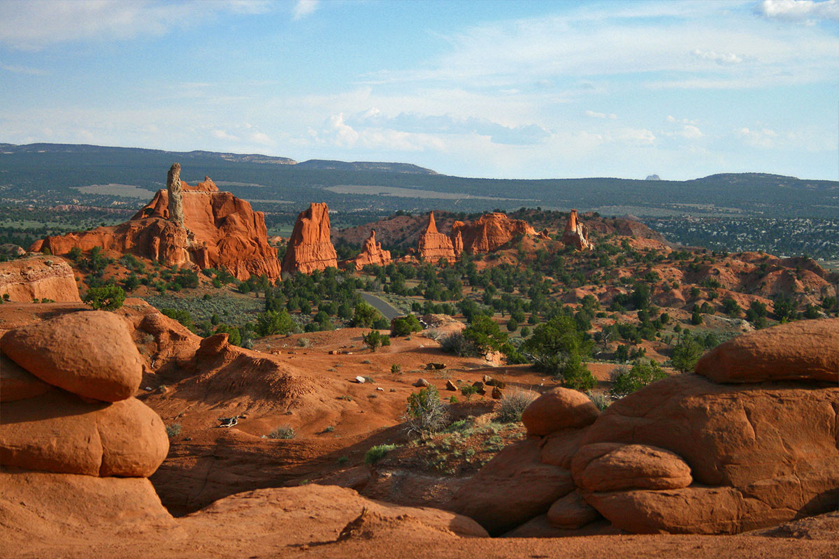
6. Kolob Canyons Road
Kolob Canyons Road, tucked away in the northwestern corner of Zion National Park, offers a scenic 5-mile drive that climbs 1,000 feet through striking red cliffs and box canyons [12]. It’s a peaceful escape from the busier main canyon of Zion.
Road Details and Access
Kolob Canyons is easily accessible from Exit 40 on Interstate 15, located 40 miles north of Zion Canyon and 17 miles south of Cedar City [11]. The journey begins at the Kolob Canyons Visitor Center, where visitors must present a valid park pass or pay an entry fee [12].
| Feature | Details |
|---|---|
| Length | 5 miles one-way |
| Elevation Gain | 1,000 feet |
| Services Nearby | Cedar City |
| Best Seasons | March through November |
| Road Type | Paved scenic drive |
Notable Viewpoints and Trails
Kolob Canyons Road provides access to several trails and viewpoints that showcase the area's natural beauty:
Timber Creek Overlook
This 1.1-mile round-trip trail offers sweeping views of the finger canyons and distant mountain peaks [10].
Taylor Creek – Middle Fork
A 5-mile round-trip hike that takes you through fascinating geological formations [10].
Kolob Arch Trail
For seasoned hikers, this 14-mile round-trip trek along the La Verkin Creek Trail leads to Kolob Arch, one of the largest natural arches in the world [10]. These trails and viewpoints make Kolob Canyons Road a hub for exploration and discovery.
Seasonal Considerations
"Looking for a landscape of beautiful box canyons and sandstone cliffs that you can explore without the crowds? While Kolob Canyons isn't exactly a secret, it's a totally separate area of Zion National Park that is not nearly as well-visited as the main canyon of Zion."
- zionadventurephotog.com [10]
| Season | Conditions | Recommendations |
|---|---|---|
| Spring | Mild temperatures | Great for hiking and photos |
| Summer | Warm days | Start early to avoid heat |
| Fall | Cool weather, fall colors | October is especially beautiful |
| Winter | Snow possible | Check road conditions before visiting |
Essential Travel Tips
- Stop by the Visitor Center first for permits and up-to-date information [12].
- Pack water and necessary supplies, as there are no services along the road [13].
- Always follow Leave No Trace principles to preserve the natural beauty [13].
Kolob Canyons Road offers a quieter, more serene way to experience the stunning red rock landscapes of Southern Utah.
7. Cedar Breaks Scenic Byway (Highway 148)
Cedar Breaks Scenic Byway takes you on a breathtaking drive through Dixie National Forest and Cedar Breaks National Monument. Along the way, you'll encounter a stunning natural amphitheater filled with intricate spirals and colorful ridges. This geological wonder is half a mile deep and stretches three miles across [14].
Route Overview
| Feature | Details |
|---|---|
| Length | 2.544 miles |
| Best Viewing Times | Early morning, sunset |
| Seasonal Access | Mid-May to mid-November |
| Key Features | Natural amphitheater, forest views |
| Wildlife | Mule deer sightings at dawn and dusk |
Scenic Highlights
- Panoramic views of the Escalante Desert
- Vistas of the Great Basin and western Nevada
- Towering ponderosa pine and spruce forests
- Seasonal wildflower meadows that add vibrant colors [16]
Seasonal Considerations
| Season | Accessibility | Notes |
|---|---|---|
| Summer/Fall | Fully accessible | Best time for scenic views |
| Winter | Closed | Sections from mile 0.2 to 19 are inaccessible [19] |
| Spring | Limited | Access depends on weather conditions |
Essential Travel Tips
- Road Closures: The byway is typically closed from mid-November to mid-May due to snowfall [17].
- Winter Access: During the off-season, Highway 143 offers limited access to the park's north and east entrances. Snowplows operate during daylight hours when weather allows [17][18].
- Winter Driving Safety: Snow tires or chains are required on Highway 143 between November 30 and March 1 [17].
Visitor Services
The Cedar Breaks Visitor Center is open from June through October. It provides essential park information, interpretive activities, and updates on current conditions [14]. For real-time updates on road conditions and closures, check the Utah Department of Transportation's website before your trip [17]. If you're looking for the most vivid views of the amphitheater, plan to visit at sunrise or sunset, when the colors are at their peak [15]. Next, dive into the Quick Route Comparison section to see how Cedar Breaks Scenic Byway stacks up against other iconic drives in Southern Utah's red rock landscapes.
Quick Route Comparison
Plan your red rock adventure with this side-by-side look at two popular scenic drives:
| Route Name | Distance | Driving Time* | Highlights |
|---|---|---|---|
| Highway 12 Scenic Byway | 123 miles | 3 hours | Dixie National Forest, Bryce Canyon, Grand Staircase–Escalante |
| Zion National Scenic Byway | 54 miles | - | Stunning sandstone cliffs |
*Driving times are estimates and don’t account for stops [20]. Be sure to check road conditions through the Utah Department of Transportation [21]. Highway 12 is perfect for a full-day journey, while Zion offers breathtaking views, especially at sunrise or sunset [1]. Head over to Travel Resources and Services for more planning tips and details.
Travel Resources and Services
Once your route is set, make use of these resources to stay informed and prepared for your journey through Southern Utah's stunning red rock landscapes. Located at 745 East Highway 89 in Kanab, the Bureau of Land Management center is a great starting point for your adventure. Open Tuesday through Saturday from 9:00 AM to 4:00 PM during summer, it offers:
- Weather updates and road condition reports
- Hiking recommendations tailored to the area
- Displays on local geology
- Archaeological insights into Grand Staircase-Escalante
The facility has 33 parking spots, including two accessible spaces. Paved sidewalks and accessible restrooms are available at the entrance, but note that some pathways to interpretive signs may be uneven [22]. Stop here to gather essential local knowledge before hitting the road.
Real-Time Road Updates
Keep track of road conditions with these trusted tools:
| Resource | Features | Access |
|---|---|---|
| UDOT Traffic Website | Updates on crashes, construction, and weather | Web browser |
| UDOT Mobile App | Traffic alerts and road condition updates | iOS/Android devices |
| Traffic Operations Center | 24/7 road condition and weather support | Phone support |
| UDOTTRAFFIC Twitter | Instant traffic updates | Social media |
Before setting out, check the Utah Department of Transportation (UDOT) Traffic website or download their app for the latest updates. The Traffic Operations Center is available 24/7 to provide real-time road and weather information, ensuring you’re ready for any unexpected changes.
Additional Support Services
Regional visitor centers in Salt Lake City, Jensen, Thompson, and St. George are excellent resources for advice on lodging, local events, and travel tips. These locations connect you to knowledgeable staff who can help refine your plans. For more detailed trip planning, explore resources provided by the U.S. Forest Service and Utah State Parks & Recreation. They offer further insights into the surrounding areas, helping you make the most of your scenic drive.
Summary
Southern Utah offers some of the most stunning red rock drives in the country. Among these, Utah Scenic Byway 12 stands out as a 124-mile All-American Road that connects Bryce Canyon to Capitol Reef, winding through secluded canyons, high plateaus, and deep valleys [23]. Here’s a quick look at seven distinct routes and what makes them special:
| Route Name | Distance | Key Features | Best For |
|---|---|---|---|
| Highway 12 Scenic Byway | 124 miles | High plateaus, deep valleys | Photography enthusiasts |
| Zion Park Scenic Byway | 54 miles | Zion-Mount Carmel Tunnel | Family adventures |
| Johnson Canyon Road | 18 miles | Remote desert scenery | Off-the-beaten-path explorers |
| US Highway 89 | 75 miles | Vermilion Cliffs views | Casual scenic drives |
| Burr Trail Scenic Backway | 66 miles | Rugged backcountry | Adventure seekers |
| Kolob Canyons Road | 5 miles | Crimson canyons | Short excursions |
| Cedar Breaks Scenic Byway | 15 miles | High-altitude vistas | Summer travelers |
"I can tread thoughtfully and lightly on these lands. Utah is not a place to be conquered, to be scrambled across for a photo op, to be rushed." [25]
To preserve these incredible landscapes, stick to designated routes, respect wildlife, and support local communities along the way. Be sure to plan ahead and follow safety tips for a smooth trip. Before hitting the road, check updates from UDOT, especially during winter months [26]. These drives aren’t just about the scenery - they’re a chance to connect with Utah’s geological beauty and cultural richness.
"Small but mighty actions make all the difference as we work together to protect our natural wonders and vibrant cultures for generations to come." [24]
FAQs
The best times to explore Southern Utah's scenic drives are spring (March–April) and fall (October). During these shoulder seasons, you’ll enjoy mild temperatures, vibrant landscapes, and fewer crowds, making it ideal for sightseeing and outdoor activities.
For a quieter experience, consider visiting in winter (November–February). While temperatures can be cooler, the serene beauty of the red rock landscapes dusted with snow offers a unique and unforgettable perspective.
The summer months (May–September) are the busiest, with hotter temperatures often exceeding 90°F. If you plan to visit during this time, start your drives early in the morning to beat the heat and avoid peak traffic.
Before heading out on a road trip through Southern Utah’s remote and rugged terrains, it’s crucial to prepare your vehicle to handle the unique conditions of the area. Start by ensuring your car is in good working order - check the brakes, tires (including the spare), battery, and fluid levels. All-terrain or high-clearance vehicles are ideal for unpaved or rough roads, but most scenic routes are accessible with standard vehicles.
Pack essential supplies, including plenty of water, snacks, a first aid kit, a flashlight, and a fully charged phone. In winter months, be prepared for snow or icy conditions in higher elevations and shaded areas - carry tire chains if necessary. Lastly, ensure your gas tank is full before entering remote areas, as gas stations can be few and far between.
Pack essential supplies, including plenty of water, snacks, a first aid kit, a flashlight, and a fully charged phone. In winter months, be prepared for snow or icy conditions in higher elevations and shaded areas - carry tire chains if necessary. Lastly, ensure your gas tank is full before entering remote areas, as gas stations can be few and far between.
Exploring Southern Utah's less-traveled roads can be an unforgettable experience, but it's important to stay prepared for the unique challenges of these remote areas. Before your trip, ensure your vehicle is in good condition, carry a full tank of gas, and pack essentials like water, snacks, a first-aid kit, and a physical map, as cell service can be unreliable.
Be mindful of seasonal conditions, especially in winter, when some roads may be closed or icy. Check local weather forecasts and road conditions ahead of time. It's also a good idea to let someone know your planned route and expected return time. By staying prepared and informed, you'll be ready to safely enjoy the stunning landscapes of Southern Utah.
Be mindful of seasonal conditions, especially in winter, when some roads may be closed or icy. Check local weather forecasts and road conditions ahead of time. It's also a good idea to let someone know your planned route and expected return time. By staying prepared and informed, you'll be ready to safely enjoy the stunning landscapes of Southern Utah.
Related Posts
April 16, 2026
April 13, 2026
March 20, 2026
