Utah is home to some of the most striking mountain ranges in the United States, each offering a mix of towering peaks, scenic trails, and recreational opportunities. From the Uinta Mountains, which feature Utah's tallest peak, to the Wasatch Range's proximity to urban centers, these ranges shape the state's geography and outdoor lifestyle. Here's a quick overview:
Uinta Mountains: Home to Kings Peak (13,528 ft), Utah's highest summit, known for its rugged wilderness and over 400 miles of trails.
Wasatch Range: Easily accessible from cities like Salt Lake City, with Mount Nebo (11,933 ft) as its tallest peak. Popular for skiing, hiking, and climbing.
La Sal Mountains: Rising from Utah's desert, Mount Peale (12,726 ft) offers a cooler escape and stunning views near Moab.
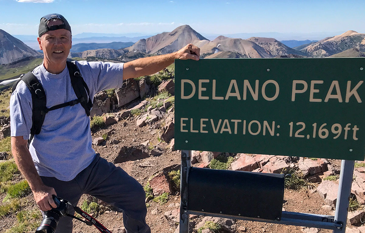
Tushar Mountains: A quieter destination featuring Delano Peak (12,174 ft), perfect for solitude and nature enthusiasts.
Other Ranges: Bear River Mountains, Canyon Mountains, Pavant Range, and Roan Cliffs provide hidden gems for hikers seeking less-traveled paths.
Utah's mountains are not just scenic - they're vital for wildlife habitats, water resources, and year-round recreation. Whether you're after challenging climbs, serene wilderness, or family-friendly trails, there's something for everyone. Read on for more details about each range, including trail tips and best times to visit.
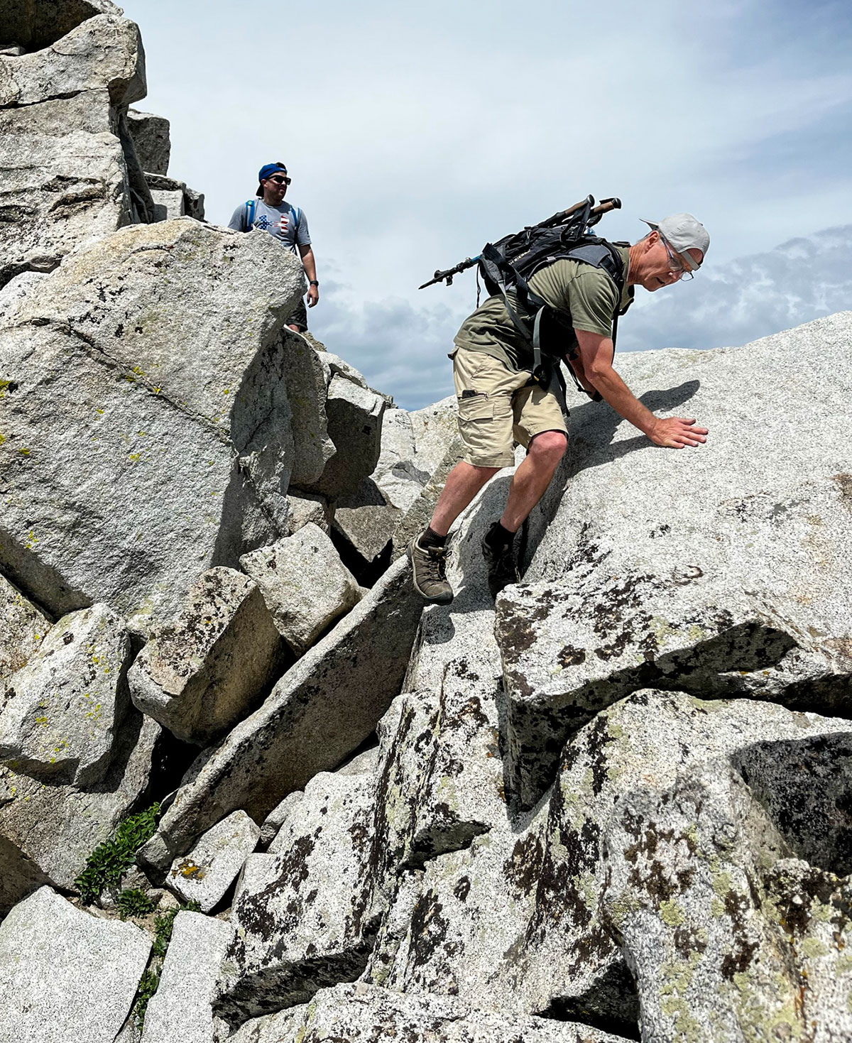
Hiking Kings Peak (tallest peak in Utah) in 2 days! (Uinta Mountains, Utah)
Uinta Mountains: Utah's Tallest Range
The Uinta Mountains stand out among Utah's ranges for several reasons. Spanning about 150 miles across northeastern Utah into northwestern Colorado, the Uintas are the only major continental range that runs east–west. This unusual orientation creates distinct weather patterns and microclimates that set them apart from the more common north–south mountain ranges.
Reaching elevations over 13,000 feet, the Uintas boast Utah’s tallest peaks and some of the most untouched wilderness in the western United States. With over 1,000 lakes and countless streams, the range is a haven for anglers and backpackers looking to escape the crowds. Unlike the more accessible Wasatch Range near Utah’s urban centers, the Uintas remain largely unspoiled and are only reachable by foot or horseback once you leave the trailheads.
The High Uinta Wilderness covers an impressive 460,000 acres, making it one of Utah’s largest protected wilderness areas. This rugged landscape transitions from dense Engelmann spruce and subalpine fir forests to vibrant alpine meadows in the summer. Above 11,000 feet, the scenery becomes strikingly stark, featuring exposed granite, permanent snowfields, and pristine alpine lakes. Among these dramatic features lies Kings Peak, the crown jewel of the range.
Kings Peak: Utah's Highest Point
At a towering 13,528 feet, Kings Peak holds the title of Utah’s highest summit and serves as the ultimate challenge for experienced hikers.
The most common route to Kings Peak starts at the Henry’s Fork Trailhead, located roughly 25 miles north of Mountain View, Wyoming. The trek is a 25-mile round trip with an elevation gain of about 4,000 feet, making it a demanding journey that typically takes two to three days. The trail meanders through thick forests, crosses multiple creeks, and eventually climbs above the treeline, where hikers are greeted with breathtaking views of the surrounding wilderness.
Reaching the summit involves navigating loose scree and exposed rocks, which can be hazardous when wet. Summer afternoons often bring thunderstorms, adding an extra layer of difficulty. On clear days, the summit rewards climbers with panoramic views, stretching from Wyoming’s Wind River Range to the distant Colorado Rockies.
Many hikers set up base camp at Dollar Lake or Painter Basin, both located about 8 miles from the trailhead. These campsites, perched above 10,000 feet, provide convenient spots to prepare for the final summit push. Water is readily available from nearby streams and lakes, but purification is essential.
The best time to climb Kings Peak is from mid-July through early September, when weather conditions are generally more stable. Snow can linger on north-facing slopes well into the summer, so early-season hikers may need microspikes or lightweight crampons for safety.
Outdoor Recreation Opportunities
The Uinta Mountains offer an impressive variety of outdoor activities, from short day hikes to multi-day wilderness adventures. The High Uinta Wilderness boasts over 400 miles of maintained trails, providing access to remote lakes, high mountain passes, and secluded campsites far from the crowds.
Backpacking is one of the best ways to experience the Uintas’ remote beauty. Popular routes include the Highline Trail, which spans over 100 miles along the range’s backbone, and shorter loops near the Mirror Lake area. While there are many established campsites, backcountry camping rules require campers to stay at least 200 feet from lakes and streams above 10,000 feet.
For those who enjoy fishing, the Uintas are a dream destination. Native cutthroat trout thrive in many of the high-altitude lakes and streams. Popular fishing spots include the Uinta River drainage, Red Castle Lake, and the countless smaller lakes scattered throughout the wilderness. A Utah fishing license is required, and some waters have special regulations to protect native fish populations.
The Mirror Lake Scenic Byway offers summer vehicle access to the western part of the range. This paved highway, open from late May until the first significant snowfall in October, climbs to over 10,000 feet and connects visitors to numerous trailheads, campgrounds, and day-use areas. Highlights along the route include Mirror Lake, Trial Lake, and the Provo River Falls overlook.
In winter, the Uintas transform into a playground for snowmobiling and cross-country skiing. The range’s higher elevations receive over 400 inches of snow annually, creating excellent conditions for winter sports from December through April. Groomed trails are accessible from several staging areas, making it easy to explore the snow-covered wilderness.
If you’re planning a trip to the Uintas, keep in mind that permits are required for overnight camping in the High Uinta Wilderness during peak season (July 1 through September 10). These permits can be reserved through Recreation.gov or picked up at local ranger stations. Group sizes are limited to 14 people, and campfire restrictions often apply at higher elevations depending on current conditions. With careful planning, the Uintas offer an unparalleled wilderness experience that showcases Utah’s rugged beauty.
Wasatch Range: Mountains Near Utah's Cities
Unlike the remote Uintas, the Wasatch Range offers a mountain experience practically at the doorstep of Utah's bustling cities. Stretching about 160 miles from southeastern Idaho through central Utah, this range forms a dramatic backdrop to the state's urban centers, rising sharply from the Salt Lake Valley. It's one of the most accessible mountain ranges in the western United States, perfect for quick day trips or extended outdoor adventures.
The Wasatch Range is a haven for outdoor enthusiasts, offering everything from leisurely hikes to demanding climbs - all just a short drive from downtown Salt Lake City. The western slopes are particularly striking, with steep elevation gains that deliver stunning views and dynamic terrain in a relatively short distance.
Thanks to its north–south alignment, the range captures moisture from Pacific storms, making it famous for its light, powdery snow. This has helped establish world-class ski resorts like Alta, Snowbird, Park City, and Deer Valley. Each section of the range has its own personality: the northern Wasatch near Salt Lake City features rugged peaks, while the central and southern areas showcase gentler slopes and valleys dotted with aspen trees that turn a brilliant gold every autumn. The proximity of these mountains to urban areas adds another layer to Utah's reputation as a hub for outdoor recreation.
Mount Nebo: The Highest Peak of the Wasatch
Standing tall at 11,933 feet, Mount Nebo is the crown jewel of the Wasatch Range. Located about 50 miles south of Salt Lake City near the town of Nephi, it’s easily reached via the scenic Nebo Loop Road, making it a favorite for hikers and climbers alike.
The Nebo Bench Trailhead, starting at 9,000 feet, offers a 4-mile trek with a 3,000-foot elevation gain. The trail winds through serene aspen and conifer forests before opening up to alpine meadows. The final stretch requires a bit of scrambling over loose rocks and steep switchbacks, but it’s a manageable challenge for seasoned hikers.
Mount Nebo’s high elevation brings unpredictable weather. Even in the summer, summit temperatures often hover between 40°F and 60°F, while the valleys below can be sweltering at over 90°F. Afternoon thunderstorms are common from July through September, so starting early is key. Reaching the summit rewards climbers with sweeping views of Utah Lake, the Great Salt Lake, and nearby peaks like Mount Timpanogos on clear days. The best time to climb is late June through early October, though snow can linger on the north-facing slopes into July. The Nebo Loop Road generally closes for winter by mid-October and reopens in late May or early June.
Other Popular Peaks and Activities
The Wasatch Range is packed with other peaks and activities that cater to all kinds of outdoor enthusiasts.
Mount Timpanogos, the range's second-highest peak at about 11,752 feet, is a standout destination. Located just east of Provo, it draws thousands of climbers each year with its iconic pyramid-shaped summit. Two popular routes, the Timpooneke Trail and the Aspen Grove Trail, lead to the top, passing landmarks like Emerald Lake along the way. While the final ascent involves some scrambling over loose limestone, the trails are well-marked and ideal for hikers in good shape.
When winter rolls in, the Wasatch becomes a skiing paradise. Resorts like Alta are celebrated for their deep powder, while Snowbird even offers year-round skiing thanks to its aerial tram.
For those who prefer quieter pursuits, the range offers plenty of hiking trails beyond its famous peaks. In Millcreek Canyon, you’ll find serene spots like Donut Falls and Lake Blanche, while Big Cottonwood Canyon boasts Brighton Lakes and Silver Lake. Mountain biking is another highlight, with Park City’s extensive trail network catering to riders of all skill levels. Several ski resorts also run their lifts during the summer, making it easy for bikers and hikers to reach higher elevations.
Rock climbing is yet another draw, with options ranging from the granite walls of Little Cottonwood Canyon to the limestone cliffs near American Fork. Thanks to its close proximity to Salt Lake City, the Wasatch has fostered a vibrant climbing community, offering challenges for both traditional and sport climbers, no matter their experience level.
La Sal Mountains: Desert Mountain Escape
Utah’s La Sal Mountains offer a striking contrast to the state’s urban-adjacent ranges, providing a high-altitude retreat right in the heart of the desert. Rising dramatically from the red rock landscape near Moab, this mountain range stretches about 20 miles from north to south, creating an unforgettable skyline. With summer temperatures in the surrounding desert often soaring past 100°F, the La Sals provide a much-needed cool escape.
The range is divided into three sections - North, Middle, and South - with the Middle group boasting the tallest peaks. One of the highlights of this area is its accessibility. The La Sal Mountain Loop Road, a scenic byway connecting Moab to Castle Valley, allows visitors to drive to elevations above 10,000 feet. Unlike Utah’s Wasatch Range, known for heavy snowfall, the La Sals experience moderate snow from December through April. This means a shorter hiking season but also quieter trails and untouched wilderness. The range transitions through diverse ecosystems, from desert scrub to lush aspen and spruce forests. In autumn, the golden hues of the aspen trees create a stunning seasonal display. The La Sals deliver a perfect mix of outdoor adventure and breathtaking natural beauty.
Mount Peale: The Highest Peak
Standing tall at 12,726 feet, Mount Peale is the crown jewel of the La Sal Mountains and Utah’s sixth-highest peak. It’s named after Albert Charles Peale, a geologist from the Hayden Survey in the 1870s, and offers hikers a rewarding climb with unmatched views of southeastern Utah.
The most popular way to reach the summit begins at the Geyser Pass Trailhead, located at around 10,400 feet along the La Sal Mountain Loop Road. This 4.5-mile round-trip hike climbs roughly 2,300 feet in elevation, starting with aspen groves and opening into alpine meadows that bloom with wildflowers in summer. The final stretch involves some scrambling over loose rock, but it’s less technical than other climbs in the region. Even in summer, summit temperatures range between 35°F and 65°F, while the desert below bakes in triple-digit heat. Afternoon thunderstorms are common from mid-July through early September, so setting out early in the morning is a smart move. From the top, hikers are treated to sweeping views of landmarks like the Colorado River, Arches National Park, the Book Cliffs, and even distant mountain ranges. The best time to hike Mount Peale is from late June to mid-October, though snow may linger on certain slopes into July.
What to See in the La Sal Range
The La Sal Mountains have much more to offer beyond Mount Peale. The La Sal Mountain Loop Road, a 62-mile scenic drive, is a major draw. It takes travelers through a variety of ecosystems, from desert landscapes to alpine forests. Keep in mind, though, that snow closes sections of the road above 8,000 feet from December through May, while lower sections remain open year-round.
For a more tranquil outing, Warner Lake is a great choice. Nestled at about 9,400 feet in a cirque surrounded by rugged peaks, this small alpine lake is ideal for families and beginner hikers. It’s accessible via a gentle 2-mile hike from the Burro Pass Trailhead, with an elevation gain of about 600 feet. While parts of the lake may stay partially frozen into early summer, conditions usually become more inviting by midsummer.
With its blend of alpine beauty and desert charm, the La Sal Mountains offer an array of activities, from hiking and scenic drives to photography. This serene, less crowded destination perfectly complements Utah’s reputation for diverse and stunning mountain landscapes.
Tushar Mountains: A Quiet Mountain Range
Nestled in south-central Utah, the Tushar Mountains offer a peaceful escape from the busier ranges in the state. Shaped by ancient volcanic activity, their rounded peaks create a striking and serene landscape perfect for those who enjoy solitude and exploration.
Although the area is accessible via a network of trails, its remote location ensures that visitors can often experience long stretches of quiet in the rugged backcountry. During summer, the higher elevations provide a cool retreat from the heat found in the lower valleys. This tranquility sets the perfect stage for adventures like summiting Delano Peak, the range's highest point.
Delano Peak: The Crown of the Tushars
Standing as the highest peak in the Tushar Mountains, Delano Peak is a must-visit for hikers. The journey typically begins at a high-elevation trailhead, reachable only with a high-clearance or 4WD vehicle due to the rough forest roads. The hike itself is moderate, making it more approachable than Utah's taller peaks. A well-marked trail leads through subalpine meadows that burst with colorful wildflowers during the summer months. Near the top, a short scramble rewards adventurers with sweeping views of the surrounding wilderness. Be sure to start early, as weather in the high elevations can shift quickly.
Reasons to Explore the Tushars
The Tushar Mountains offer more than just their highest summit. They provide a rare backcountry experience that’s increasingly hard to find in more popular destinations. Summer brings vibrant displays of alpine wildflowers, a testament to the region's volcanic heritage, while autumn transforms the aspen groves into golden treasures. This seasonal charm, paired with the range's solitude, creates a truly immersive wilderness adventure.
Wildlife enthusiasts will find plenty to marvel at, from deer and bears to a variety of birds adapted to the high-altitude environment. For anyone craving an escape into pristine nature and genuine tranquility, the Tushar Mountains promise an unforgettable adventure far from the crowds and chaos of busier trails.
Other Mountain Ranges and Peaks in Utah
Utah boasts several smaller mountain ranges that may not grab the spotlight like the Wasatch or Uinta ranges, but they offer their own charm and a sense of quiet adventure. These hidden gems highlight the state's diverse landscapes and provide unique opportunities for those seeking paths less traveled.
Bear River Mountains: Logan Peak
Logan Peak, the highest point in the Bear River Mountains, is a haven for year-round hiking and breathtaking views. The area transitions beautifully from lush valleys to open, high-altitude terrain, making it a perfect spot to explore northern Utah's natural beauty. With its accessible trails and sweeping vistas, Logan Peak is a must-visit for those looking to experience serenity amidst stunning scenery.
Canyon Mountains: Fool Creek Peak
Tucked away in western Utah, the Canyon Mountains offer an unexpected alpine retreat in the middle of desert terrain. Fool Creek Peak, the tallest point in this range, provides a true wilderness adventure as you ascend from arid landscapes into cooler, forested zones. Due to the remote nature of the trail, it's wise to bring navigation tools and emergency supplies. This peak offers an unforgettable blend of solitude and natural beauty.
Pavant Range and Roan Cliffs
In central Utah, the Pavant Range and Roan Cliffs present tranquil escapes for outdoor enthusiasts. The Pavant Range features expansive views and forest roads that are easy to explore, while the rugged Roan Cliffs, shaped by ancient volcanic activity and erosion, invite adventurers to hike, camp, and spot wildlife. Each of these locations offers a peaceful retreat and showcases the diverse terrain Utah has to offer.
Tips for Visiting Utah's Mountains
Prepare for your mountain adventure with these seasonal insights and wildlife tips.
Best Times to Visit
Utah's mountains offer something special in every season, but timing your visit can make all the difference:
Spring (March–May) and Fall (September–November): These seasons bring mild weather and fewer visitors, making them ideal for hiking and camping without the crowds[1][2][4].
Summer (June–August): This is the busiest time of year. While lower elevations can get quite hot, higher altitudes stay refreshingly cool. Keep in mind, some areas at higher elevations might not fully open until mid or late summer due to lingering snow[3].
Winter (December–February): Utah's mountains transform into a haven for snow sports, boasting what many call the "Greatest Snow on Earth." However, heavy snow and icy conditions can limit access to certain areas[2][4].
No matter the season, understanding local wildlife is key to a safe and enjoyable trip.
Wildlife Considerations
Utah’s mountain landscapes are alive with wildlife, offering a glimpse into the region's natural beauty. Among the most iconic inhabitants are the roughly 1,500 mountain goats that roam the peaks[3]. If you encounter these animals, especially males during their November breeding season, it’s best to keep a safe distance. They can become more aggressive during this time, so giving them space ensures both your safety and theirs.
Enjoy the mountains, but always respect the natural world around you!
Conclusion: Utah's Mountain Ranges
Utah's mountain ranges are a treasure trove of breathtaking landscapes and endless adventure. From the towering Kings Peak in the Uinta Mountains to the dramatic meeting of desert and alpine in the La Sal range, each range has its own story to tell and experiences to offer.
For those living near the Wasatch Front, the Wasatch Range provides easy access to outdoor escapes. In contrast, the Tushar Mountains promise a more secluded and tranquil wilderness experience. Whether you're drawn to steep climbs, leisurely family hikes, or thrilling winter sports, Utah's peaks have something for everyone.
These ranges not only provide recreation but also serve as vital habitats for wildlife and essential sources of water. Exploring them means embracing their unique characteristics - like the easily accessible Bear River Mountains or the hidden treasures of the Pavant and Canyon Mountains. From the heights of Kings Peak to the summit of Mount Nebo, there's a challenge and a reward for adventurers of all skill levels.
To make the most of your time in Utah's mountains, preparation is key. Knowing the seasonal conditions, respecting wildlife, and following safety guidelines will enhance your experience while preserving these natural wonders for others. Whether you're watching the sun rise over Utah Valley from Mount Nebo or camping under a canopy of stars in the Uinta Wilderness, Utah's mountains promise unforgettable moments that bring you closer to the untamed beauty of the state.
FAQs
When is the best time to visit Utah’s mountain ranges for hiking and outdoor activities?
The ideal time to enjoy Utah's mountain ranges for hiking and outdoor adventures is spring (March to May) and fall (September to November). These seasons offer mild temperatures, which make exploring the outdoors, especially at higher elevations, much more comfortable.
If you're planning a summer trip, be prepared for hot conditions in the lower areas. However, summer is great for tackling trails at higher altitudes where it's cooler. Winter, on the other hand, transforms Utah into a haven for skiing and snow sports, with its snow-covered peaks providing the perfect backdrop. Choose your timing based on the activities you want to enjoy and the elevation of the areas you plan to visit.
What makes the Uinta Mountains unique compared to other mountain ranges in Utah?
The Uinta Mountains are unique in that they stretch east to west, unlike most mountain ranges in Utah, which typically run north to south. This unusual alignment significantly influences the region's weather patterns, leading to distinct microclimates. Summers in the Uintas are often hot and dry, while winters bring cold temperatures and significant snowfall, characteristic of high-altitude environments.
By comparison, the Wasatch Range plays a different role in shaping local weather. Its orientation helps channel westerly winds, contributing to the heavy snowfall that makes the area a prime destination for winter sports. The Uintas' one-of-a-kind geography and climate offer a dynamic setting that draws outdoor enthusiasts year-round.
What should hikers know before climbing Kings Peak in the Uinta Mountains?
Hikers aiming to conquer Kings Peak should set out early in the day to steer clear of the afternoon thunderstorms that frequently roll through the area. Weather in the mountains can change on a dime, so it’s smart to pack layers, waterproof gear, and warm clothing to stay comfortable if temperatures suddenly plunge at higher elevations.
Don't forget to carry plenty of water, and consider bringing a dependable water filtration system. While there are natural water sources along the way, they’re untreated and not safe to drink without proper filtration. The trail also features some tricky sections, like boulder fields, so sturdy footwear and careful route planning are a must. Before heading out, take the time to check the latest weather forecasts and trail conditions to make your hike both safe and enjoyable.
Mark has spent 40+ years exploring and documenting all of Utah, and for the past five years he has been a weekly featured guest on Utah's KSL Outdoors radio show. He is the former Director of Tourism over southwestern Utah which includes areas...