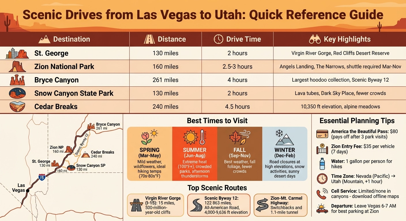
Las Vegas isn't just about casinos and nightlife - it’s also a perfect starting point for breathtaking road trips into Utah’s stunning landscapes. Within a few hours' drive, you can explore iconic national parks, scenic byways, and hidden gems. Whether you're planning a weekend getaway or a longer adventure, here’s what you need to know:
Top Destinations: Zion National Park (2.5 hours), Bryce Canyon (4 hours), Arches (6.5 hours), and Cedar Breaks.
Key Scenic Routes: Virgin River Gorge (I-15), Scenic Byway 12, and Zion-Mt. Carmel Highway.
Must-Have Pass: The $80 America the Beautiful Pass covers all U.S. national parks and pays off after three visits.
Timing Tips: Spring and fall offer mild weather; summer can bring extreme heat, while winter may close some roads.
Practical Advice: Pack water, snacks, and offline maps. Leave Vegas early to avoid traffic and secure parking at popular spots like Zion.
From towering cliffs to slot canyons, these drives offer unforgettable views and adventures. Keep reading for detailed routes, stops, and tips to make the most of your trip.
Las Vegas to St. George via I-15 and Virgin River Gorge
This 134-mile journey along I-15 takes you through the breathtaking Virgin River Gorge, a 15-mile stretch of highway that stands as an engineering feat. Built in 1973 at a cost exceeding $1 million per mile, the project required the Virgin River to be re-channeled 12 times to ensure a safe and functional route. The drive typically takes about 1 hour and 45 minutes.
What to See Along the Route
The Virgin River Gorge is a visual masterpiece, with towering limestone and sandstone cliffs that date back 500 million years. These cliffs, marked by dynamite-induced striations, rise dramatically above the highway.
With roughly 23,000 vehicles passing through the gorge daily, many travelers miss its most striking views by rushing along the route. For a better experience, consider stopping at the Virgin River Gorge Rest Area. Here, you'll find picnic tables, interpretive signs explaining the area's geology, and elevated views of the canyon. Photographers will especially appreciate the vibrant peach, gold, and fiery tones at sunrise or sunset.
However, be prepared for the road's sharp curves, as this stretch is notorious for challenging driving conditions and a history of accidents. If you venture to informal pullouts near the riverbed, keep an eye out for flash floods after storms.
Once you've soaked in the gorge's beauty, continue on to St. George, where desert adventures await.
Things to Do in St. George
St. George offers a variety of attractions set against a stunning desert backdrop. The Red Cliffs Desert Reserve spans 60,000 acres, featuring red rock canyons and waterfalls perfect for hiking. For a unique cultural experience, check out the Tuacahn Amphitheatre, which stages professional outdoor performances framed by towering red cliffs.
Other must-visit spots include Pioneer Park, a 52-acre area with the "St. George Narrows", a narrow slot-canyon formation, and Bloomington Petroglyph Park, where you can view ancient rock carvings.
When planning your trip, avoid heading north on Friday afternoons or south on Sunday afternoons, as traffic can add up to 3 hours to your travel time. Additionally, keep your speed in check when entering Utah - state troopers frequently patrol the area.
Las Vegas to Zion National Park via I-15
The drive from Las Vegas to Zion National Park spans about 160 miles along I-15 and takes roughly 2.5 to 3 hours. It’s a journey that transitions from the vibrant energy of Las Vegas to the tranquil beauty of Zion’s sandstone cliffs. Plan for extra time to make stops at scenic spots like the Virgin River Gorge, St. George, or Hurricane.
To ensure parking at the Zion Visitor Center, aim to leave Las Vegas between 6:00 AM and 7:00 AM, arriving by 9:00 AM. Keep in mind that Utah operates on Mountain Time, which is one hour ahead of Nevada’s Pacific Time. Since cell service can be spotty in areas like the Virgin River Gorge and Zion Canyon, downloading offline maps before you leave is a smart move.
The park entrance fee is $35 per vehicle, valid for seven days, but frequent visitors may find the $80 America the Beautiful Annual Pass more economical, as it grants access to all national parks. Stock up on water and snacks in St. George or Hurricane, as options near the park are limited and can be pricey. During summer, when temperatures can surpass 100°F, it’s recommended to carry at least one gallon of water per person.
Zion Canyon Scenic Drive
Once inside Zion, the Zion Canyon Scenic Drive is your gateway to the park’s iconic landmarks. From March through November, private vehicles are not allowed on this road, so you’ll need to take the free park shuttle to reach the major trailheads. If parking at the Visitor Center is full, you can park in Springdale and use the shuttle to access the park entrance.
Angels Landing is one of Zion’s most famous hikes, featuring a challenging chain-assisted section with steep 1,000-foot drops on both sides. To hike this trail, you’ll need a permit, which can be obtained through the lottery system on Recreation.gov. You can apply months in advance via the seasonal lottery or use the day-before lottery option. Be aware that Angels Landing will be closed for trail maintenance from April 20–23, 2026.
For a different kind of adventure, The Narrows invites you to hike directly through the Virgin River, surrounded by towering canyon walls that reach up to 1,000 feet. Gear rentals, including neoprene socks, waterproof canyon boots, and a sturdy pole, are available in Springdale for $32–$50 per person. These items are essential for safely navigating the cold, uneven riverbed. If you’re looking for a more relaxed experience, the Emerald Pools trails offer routes to waterfalls and lush hanging gardens. Alternatively, the paved Riverside Walk, a 2.2-mile round trip that’s wheelchair accessible, provides a scenic introduction to The Narrows.
Visitor Information for Zion
Spring (March to May) and fall (September to November) are ideal times to visit Zion, offering pleasant hiking weather without the intense summer heat or the risk of snow at higher elevations. During peak season, the park’s shuttle service operates frequently, stopping at key locations such as the Temple of Sinawava (entrance to The Narrows), The Grotto (Angels Landing trailhead), and the Emerald Pools trailhead.
Important for 2026: Starting June 7, oversized vehicles taller than 11'4" or wider than 7'10" will no longer be allowed through the Zion-Mt. Carmel Tunnel. If you’re driving an RV or another large vehicle, plan ahead or explore alternative transportation options within the park.
Las Vegas to Bryce Canyon National Park via Scenic Byway 12
The journey from Las Vegas to Bryce Canyon National Park covers 261 miles and takes about 4 hours if you stick to I-15 North, then connect to UT-20 or UT-14, and finally US-89 before reaching Scenic Byway 12. Keep in mind that crossing from Nevada's Pacific Time into Utah's Mountain Time will cost you an hour, so plan your departure to ensure you arrive before sunset. Entrance fees are required at Bryce Canyon, but if you're planning multiple national park visits, the America the Beautiful Annual Pass might save you money. For an added bonus, consider a detour through Zion National Park for even more stunning views.
If you’re up for a slightly longer but more scenic route, take the 242-mile drive through Zion via UT-9. This option adds some time - 4.5 to 5 hours total - due to winding roads and reduced speed limits. Be sure to fill up your gas tank in Panguitch or Escalante, as fuel stations are scarce along the way. Also, download offline maps since cell service is limited, especially in areas like Boulder Mountain and other canyon regions.
For those who want a drive filled with breathtaking views, Scenic Byway 12 is a must.
Driving Scenic Byway 12
Scenic Byway 12, an All-American Road stretching 122.863 miles, connects Bryce Canyon and Capitol Reef National Parks. The route climbs from 4,000 feet to a staggering 9,636 feet at its highest point on Boulder Mountain, the tallest timbered plateau in North America. Along the way, you’ll pass through an incredible variety of landscapes, from red rock deserts to lush subalpine forests.
Just 13 miles west of Bryce Canyon, Red Canyon offers a sneak peek of what’s to come, with its striking red rock pillars and two famous arches. Further along the byway lies The Hogsback, a narrow ridge between Escalante and Boulder. With steep drop-offs and soft shoulders, this section demands careful driving.
Other highlights along Scenic Byway 12 include Kodachrome Basin State Park, where a $10 day-use fee grants access to 67 unique sandpipe formations, and Lower Calf Creek Falls, a 126-foot waterfall reached via a 5.5-mile round-trip hike. The Grand Staircase–Escalante National Monument, covering 1.8 million acres, showcases a vast array of geological wonders. Fall brings cool, dry weather, while spring bursts with wildflowers, making October, March, and April particularly enjoyable times to visit.
When you finally reach Bryce Canyon, the scenery only gets better.
Bryce Canyon is home to the largest collection of hoodoos in the world - those quirky, weather-sculpted rock spires formed by freeze-thaw cycles at high altitudes. The best way to take in the amphitheater’s beauty is from viewpoints like Sunrise Point, Sunset Point, and Inspiration Point, all connected by a paved rim trail. For a more intimate experience, the 1.3-mile Navajo Loop Trail leads you down into the canyon, passing iconic spots like Thor’s Hammer and the narrow Wall Street section.
At night, Bryce Canyon transforms into an astronomer’s paradise. On a clear evening, you can see around 7,500 stars, with the Milky Way painting a vivid streak across the sky. The park also offers ranger-led stargazing programs and full-moon hikes - check the schedule to see what’s available during your visit. Spring (March to May) and fall (September to November) are ideal for hiking, thanks to mild temperatures. Even in summer, the park’s high elevation might surprise you with cooler weather, so bring a light jacket just in case.
While Zion and Bryce Canyon are known for their towering cliffs and steep canyons, Snow Canyon offers a different kind of beauty - one that stretches across Utah's diverse terrain. Just 130 miles from Las Vegas, it's a quick 2-hour drive along I-15 North. The park spans 7,400 acres and offers a quieter, equally captivating experience. Entrance fees are $20 per vehicle for non-residents and $15 for Utah residents.
What sets Snow Canyon apart is its dramatic mix of geological features. Red and white Navajo sandstone cliffs sit alongside ancient basalt lava flows, remnants of volcanic activity from over 27,000 years ago.
In December 2025, the park was recognized as an Urban Night Sky Place by DarkSky International, making it an incredible destination for stargazing. For the best weather, visit in spring (March to May) or fall (September to October), as summer temperatures often top 100°F.
What to Do at Snow Canyon State Park
The park's unique mix of sandstone and lava formations provides the perfect backdrop for outdoor adventures. With over 38 miles of hiking trails, 170 rock climbing routes, and paved paths for cycling, there's something for everyone.
Lava Flow Trail: This 2.3 to 2.5-mile round-trip hike takes you through volcanic fields and leads to three lava tubes. Bring a flashlight if you plan to explore the tubes.
Petrified Sand Dunes Trail: A 1.2 to 1.4-mile route where you can scramble over ancient sandstone dunes, perfect for families and photographers.
Jenny's Canyon: A short, 0.5-mile walk into a narrow slot canyon with sculpted walls. Note: it’s closed mid-March to mid-June to protect nesting falcons.
Whiptail Trail: A 6-mile paved path ideal for cyclists and e-bike riders. Class 1 e-bikes are available to rent from Rampage Rentals.
Butterfly Trail: A 2-mile hike connecting petrified dunes and lava fields with scenic views.
Scout Cave Trail: A moderate 3.6 to 4.4-mile hike through lava rock, leading to a cave with panoramic vistas.
For sunset lovers, the Petrified Sand Dunes glow beautifully in the evening light. If you're looking for panoramic views without entering the park, the Snow Canyon Scenic Overlook off Highway 18 is a great option.
Other Stops Near St. George
Once you've explored Snow Canyon, there are plenty of nearby attractions to make your trip even more memorable.
Visit the Kayenta Art Village in Ivins, where local galleries and studios are nestled among features like the Desert Rose Labyrinth and Xetava Gardens Café. If you're craving a quick coffee break, FeelLove Coffee near the park's southern entrance is a great choice for pastries and lattes.
For a scenic drive, consider passing through the Shivwits Band of Paiutes Reservation. The peaceful, winding roads here are surrounded by stunning red rock formations. If you're looking for a local treat, stop by Swig for a "dirty soda", a regional favorite. Lastly, the Tuacahn Amphitheatre, located at the base of dramatic red cliffs, hosts Broadway-style musicals and concerts in an unforgettable outdoor setting. These stops add an extra layer of charm to your journey from Las Vegas into Utah's stunning landscapes.
This scenic drive takes you from the desert heat of Las Vegas to the cool, high-altitude serenity of Cedar Breaks National Monument. The journey spans about 240 miles and takes roughly 4.5 hours, climbing to an elevation of over 10,350 feet.
Start by heading north on I-15 from Las Vegas. Take Exit 16 and follow Highway 9 east through Zion National Park. Along the way, you'll pass through the 1.1-mile Zion–Mount Carmel Tunnel and navigate sharp switchbacks on the park's east side. After exiting Zion at the East Entrance, continue on Highway 9 until you reach U.S. Highway 89 North. From there, turn left onto Utah Highway 14 West (known as the Cedar Mountain Scenic Byway), and then take a right onto Utah Highway 148 North to arrive at Cedar Breaks. If you're driving a large RV, make sure to check tunnel size restrictions and permits required for Zion.
Cedar Breaks, perched at 10,350 feet on the Markagunt Plateau, offers a refreshing escape from the summer heat. While Zion can hit 100°F, temperatures at Cedar Breaks usually stay in the 70s or 80s during the day, with nighttime lows dipping into the 30s. Pack layers to stay comfortable. The monument features a stunning natural amphitheater that’s half a mile deep and three miles wide, filled with colorful stone hoodoos and spires. In fact, experts have identified over 50 different hues in the limestone formations. As Zion National-Park dot com puts it:
This drive not only transitions from desert to canyon landscapes but also adds a breathtaking alpine experience to your Utah adventure.
What to See at Cedar Breaks
Once you've conquered the elevation, Cedar Breaks rewards you with incredible views of its amphitheater. Hike trails like the Spectra Point Viewpoint or the South Rim Trail to see ancient bristlecone pines, some of the oldest trees on Earth. A scenic 5-mile drive through the monument takes about 30 to 45 minutes, with several overlooks where you can stop and take in the scenery.
July is a particularly special time to visit, as the subalpine meadows burst with wildflowers during their brief growing season. For stargazers, Cedar Breaks is an official International Dark Sky Park, offering unparalleled views of the night sky. Driving along Highway 14 toward the monument? Be sure to stop at the paved pull-off near mile marker 14 for a distant view of Zion's formations. Keep in mind there are no dining options or accommodations within the monument, so pack food and plenty of water. Entrance fees are $4 per person (ages 16 and up) from late May to mid-October, and camping at Point Supreme costs $14 per night.
When to Visit Cedar Breaks
The main road through Cedar Breaks, State Route 148, is closed in winter due to heavy snowfall, typically from mid-November to late May. However, the park remains open for winter activities like snowshoeing, cross-country skiing, and snowmobiling - just note that vehicle access won’t be possible. Before planning your trip during late spring or fall, check the Utah Department of Transportation (UDOT) website for current road conditions.
Fall is another spectacular season to visit, especially from late September to early October, when the aspen trees turn vibrant shades of yellow, orange, and red. For the best views, explore the "Fall Color Loop", which includes SR 14, Highway 148, and Highway 143. Summer is perfect for wildflowers and hiking, though be aware of afternoon thunderstorms, which can make high overlooks dangerous during lightning storms. Due to the high elevation, you may experience shortness of breath or fatigue, so visitors with heart or respiratory issues should consult a doctor before traveling. Admission is free in winter when the road is closed to vehicles.
Planning Your Scenic Drive
To get the most out of your Utah road trip, a little preparation goes a long way.
Road Conditions and Drive Times
Before hitting the road, check the latest updates using Nevada 511 and UDOT Traffic websites. Utah's Traffic Operations Center operates 24/7, offering real-time information through over 1,200 cameras and 200 message boards. These tools keep you informed about construction zones, accidents, and weather-related delays. You can also call 511 in either state or download mobile apps to access live traffic feeds and even track snowplows during the winter.
Spring (March to May) and fall (September to November) are ideal for driving, with daytime temperatures usually ranging from the 70s to 80s. Summers can be scorching - Las Vegas often tops 100°F - making outdoor activities risky during midday. Winter brings sunny skies to the desert but can create hazardous conditions in mountain areas, where snow and ice may close roads without warning. Utah uses a color-coded system for weather impacts: Green means minimal issues, Yellow signals minor or occasional disruptions, and Red warns of significant travel difficulties.
With road conditions in mind, make sure to pack the essentials for a safe and enjoyable trip.
What to Pack
Packing smartly can make all the difference when you're exploring Utah's diverse landscapes. First and foremost, bring at least 1 gallon of water per person for hikes - even in cooler months - because the desert air is incredibly dry. Offline maps are a must, as cell service can be unreliable or completely unavailable in remote canyon areas. Let someone know your planned route and estimated return time before you set out.
Dress in layers, as temperatures can plummet after sunset, and high-elevation areas like Bryce Canyon (over 8,000 feet) stay much cooler than Las Vegas, even in summer. Essentials include a wide-brimmed hat, high-SPF sunscreen, polarized sunglasses, and sturdy hiking boots. For your vehicle, pack a spare tire, jumper cables (or a portable jump starter), and an emergency kit. If you're planning specific activities, such as hiking The Narrows in Zion, consider renting neoprene socks and waterproof boots (around $32 per person). Lastly, a portable cooler for snacks and picnic lunches is a great idea since food options are scarce between the parks.
Main Stops and Attractions Along the Routes
Planning a road trip from Las Vegas into Utah means immersing yourself in dramatic canyon landscapes and iconic rock formations. To help you make the most of your journey, here’s a breakdown of both major attractions and lesser-known gems worth adding to your itinerary.
Major Scenic Stops
The Virgin River Gorge, located along I-15, marks your entry into Utah’s stunning red rock country. This stretch of road winds through towering rock layers, offering breathtaking views as you approach the state.
Once in Utah, Zion National Park is an absolute highlight. As the 4th most visited national park in the U.S., it offers unforgettable hikes like Angels Landing and The Narrows. Picture yourself wading through the Virgin River, surrounded by canyon walls that soar 1,500 feet above you.
Next up is Bryce Canyon National Park, home to the largest collection of hoodoos on the planet. These unique rock spires fill the Bryce Amphitheater, creating a surreal landscape. Arriving at sunrise is your best bet to avoid the crowds and soak in the beauty.
For a quieter alternative, head to Cedar Breaks National Monument. Perched at a higher elevation, it also features hoodoo-filled amphitheaters but with far fewer visitors.
Closer to St. George, Snow Canyon State Park offers a mix of red rock formations, lava tubes, and slot canyons. It’s a fantastic spot for hiking, with an entry fee of $15 per vehicle.
Just over the Nevada border, Valley of Fire State Park is another must-see. Known for its fiery red sandstone formations and ancient petroglyphs, it makes for a perfect first or last stop on your trip.
Lesser-Known Attractions
If you’re looking to escape the crowds, these hidden gems offer a more peaceful experience:
The Red Cliffs Desert Reserve is ideal for serene canyon hikes and even features seasonal waterfalls.
Near Zion’s entrance, Grafton Ghost Town preserves a slice of history with its 1859 Mormon settlement. It’s also a favorite spot for photographers.
The Belly of the Dragon, a man-made tunnel near Mt. Carmel Junction, offers a quirky roadside stop. Walking through the tunnel feels like stepping into a dragon’s digestive tract - a fun and unusual experience.
Around Kanab, the Toadstool Hoodoos provide a short 1.5-mile hike to see mushroom-shaped sandstone formations.
The Moqui Cave & Sand Caves are quick but fascinating stops for cave exploration and a bit of adventure.
In Nevada, the Lost City Museum in Overton showcases Ancestral Puebloan artifacts from areas flooded during the creation of Lake Mead.
For families, Coral Pink Sand Dunes State Park is a hit. The pink-hued dunes are perfect for sandboarding or sledding, and rental equipment is available for about $25.
Whether you’re drawn to iconic parks or hidden treasures, this route offers something for everyone.
Conclusion
The drive from Las Vegas to Utah offers a dramatic shift from the glittering neon lights of the city to the awe-inspiring red rock landscapes of towering cliffs, hoodoos, and slot canyons. With Utah's five national parks located within about 300 miles of each other, you can explore multiple breathtaking natural wonders in a single trip lasting anywhere from 5 to 10 days. Careful planning and practical tips can make the journey as smooth as it is unforgettable.
The timing of your visit plays a big role in your experience. Spring (April through May) and fall (September through October) are ideal, offering mild weather and fewer crowds. On the other hand, summer often means extreme heat and busier parks. Don’t forget to prepare in advance - secure permits for popular hikes like Angels Landing and download offline maps to navigate areas with limited cell service.
These drives are more than just a way to travel - they’re an experience in themselves. Scenic routes like Byway 12 showcase some of the most stunning roadways in the country, making the journey as memorable as the destinations.
So, grab your camera, top off your gas tank, and prepare to immerse yourself in landscapes unlike any other.
FAQs
How many days do I need for Zion and Bryce from Las Vegas?
A trip of 1 to 3 days works well for visiting Zion and Bryce Canyon from Las Vegas. However, dedicating 2 days strikes the perfect balance, giving you enough time to explore both parks and take in their main attractions.
Do I need reservations or permits for Zion hikes and shuttles?
You don’t need a permit or reservation to hop on the Zion shuttle or explore most parts of Zion National Park. That said, permits are necessary for certain activities like backpacking, canyoneering, and some technical routes. Be sure to review the park’s official guidelines ahead of your visit to avoid any surprises.
What’s the best route if I’m driving an RV or oversized vehicle?
The ideal way to travel from Las Vegas to Utah in an RV or oversized vehicle is by taking Interstate 15. This highway is designed to accommodate larger vehicles and conveniently leads to major destinations like Zion National Park, Bryce Canyon National Park, and Capitol Reef National Park.
For those seeking a more scenic drive, Byway 12 is another option that can support RVs. However, it’s crucial to check road conditions and any restrictions ahead of time. Also, make sure to review regulations for oversized vehicles to avoid any surprises along the way.