Utah is home to thousands of ancient petroglyphs etched into sandstone cliffs, offering a glimpse into over 8,000 years of history. These rock carvings, created by Native American tribes and ancient cultures, are scattered across the state and range from roadside panels to remote, hike-accessible locations. Here's a quick overview of what you'll learn in this guide:
Access Details: Directions, parking info, and entry costs (many are free).
Visitor Tips: Best seasons to visit, what to bring, and preservation etiquette.
Regional Highlights: Southeastern, Northeastern, and Southwestern Utah offer unique styles and histories.
Whether you're planning a quick stop or a deeper dive into Utah's ancient rock art, this guide provides everything you need to know to make your visit memorable and respectful.
Utah Petroglyph Sites Comparison: Locations, Access, and Visitor Information
Utah Petroglyph Sites Comparison Guide: Accessibility and Features
In the YouTube videos below you’ll find 4 additional areas that we don’t cover in this article, but might be of interest to you.
3 best petroglyph panels Utah
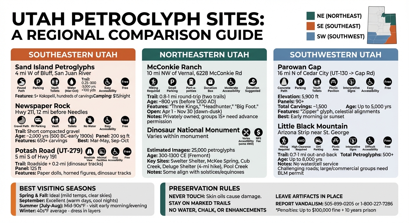
Southeastern Utah Petroglyph Sites
Southeastern Utah is home to some of the most accessible and fascinating petroglyph sites in the state. Around Bluff and Moab, visitors can find roadside panels and short trails leading to remarkable rock art collections, making these sites perfect for those with limited time or mobility.
Situated about 4 miles west of Bluff along the San Juan River, the Sand Island Petroglyphs stretch over 100 yards along a canyon wall [6]. To get there, head west on Highway 191 for 4.2 miles, turn left at the Sand Island sign, and then right at the base of the hill. The parking area is just 0.2 miles ahead.
The main panel, located near the entry road behind a chain-link fence, is easily accessible via a 0.25-mile paved path. The artwork here spans an impressive timeline of 300 to 3,000 years, showcasing styles from the Archaic period through the Ancestral Puebloan era, along with carvings from the Ute and Navajo peoples [6]. Among the hundreds of figures, you’ll spot at least five depictions of the iconic Kokopelli. A newer 1-mile roundtrip gravel trail on the east side of the campground also leads to smaller panels for those looking to explore further.
"The roadside Sand Island Petroglyphs Panel is a great stopping point on your way to and from other Bears Ears area destinations." - Bluff Utah [6]
Visiting the site is free, though camping nearby costs $15 per night. Water is available from March through October, and vault toilets are on-site. Sand Island also serves as a convenient starting point for trips to Valley of the Gods and Goosenecks State Park.
For those seeking more remote adventures, the San Rafael Swell offers a mix of eerie Barrier Canyon Style figures and traditional Fremont art [14]. One of the highlights is the Rochester Rock Art Panel, perched on a rocky point overlooking the Muddy River. This site features a fascinating blend of prehistoric Fremont and Barrier Canyon Style art, alongside more modern depictions like horses. The dark desert varnish provides excellent contrast for the carvings, making them ideal for photography [14]. Access involves a short 1/2-mile hike from a gravel road [14].
Black Dragon Canyon is another must-see, named after a pictograph resembling a flying dragon. The canyon walls are adorned with an array of other pictographs and petroglyphs, which can be reached via roadside access or a short hike. However, the last 1/2 mile may be washed out, so plan accordingly [15]. For the more adventurous, the Head of Sinbad area features two Barrier Style pictograph panels protected by a log fence. These are accessible via graded dirt roads and a concrete underpass [15]. Critical note: Be cautious of weather conditions, as wet roads can quickly become impassable [15].
Here’s a quick overview of the accessibility and highlights of these remote sites:
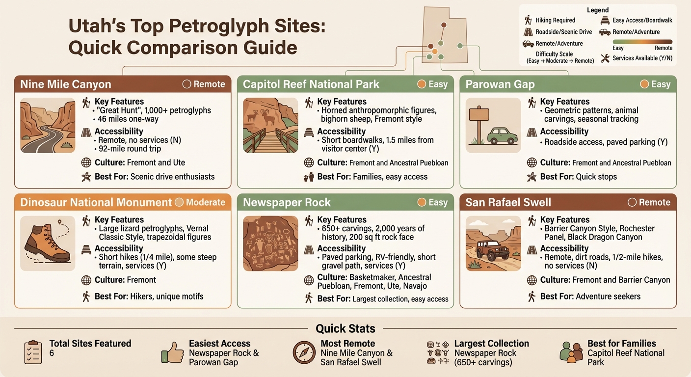
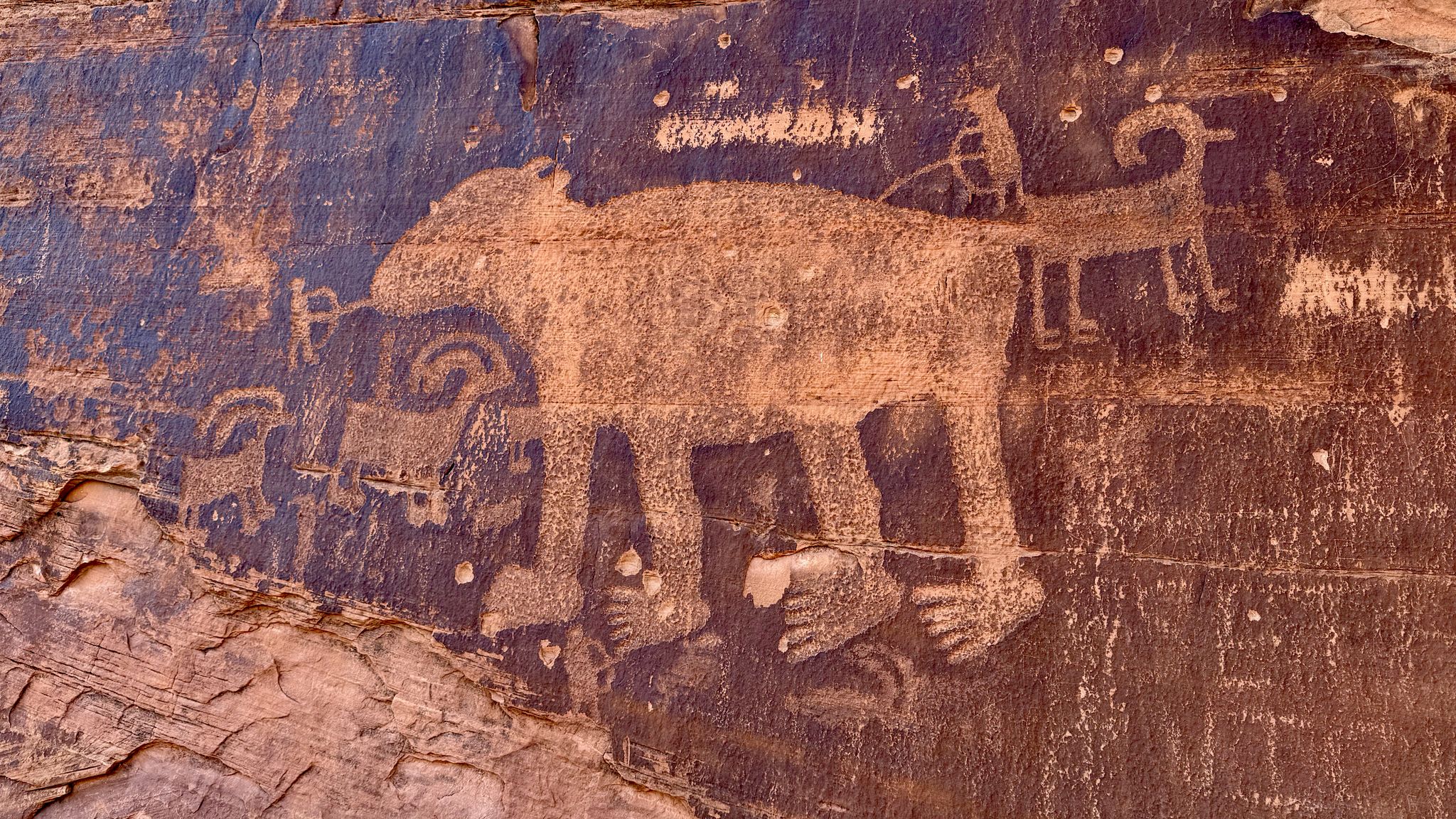
Located along Highway 211 in the Indian Creek Corridor, Newspaper Rock lies about 12 miles before the Needles District of Canyonlands National Park[9]. Known as Tse' Hane, or "rock that tells a story", in Navajo, this 200-square-foot panel features over 650 individual carvings that span about 2,000 years.
The site offers paved parking with pull-through spaces for RVs, along with a short, compacted-gravel path leading to the panel [8]. The carvings reflect a mix of cultures, including Basketmaker, Ancestral Puebloan, Fremont, Ute, Navajo, and even early Anglo-American explorers. The oldest carvings date back to around 500 B.C., while more recent additions were made in the early 20th century [8]. Pay attention to the lighter carvings, which are newer Ute and Navajo works, and contrast them with the darker, older Ancestral Puebloan designs. The imagery includes deer, buffalo, pronghorn antelope, hunters, and riders on horseback [9].
Entry is free, and while the site has vault toilets, it lacks water, picnic tables, and grills. Plan your visit between March and late May or September through October to avoid the area's extreme heat [9].
Capitol Reef National Park holds a special place in the history of the Fremont Culture, as it was here that archaeologists first identified this ancient group [6][8]. The Fremont people lived in the area for roughly 1,000 years, from 300 to 1300 CE [6]. The park's main petroglyph panels are just 1.5 miles east of the visitor center along Highway 24. Two wooden boardwalks provide easy access to these fascinating carvings, which feature the Fremont's signature style: trapezoidal anthropomorphic figures with horned headdresses, jewelry such as ear bobs, and depictions of bighorn sheep [6][8]. Binoculars can help you spot some of the fainter carvings [6].
Unlike Nine Mile Canyon, Capitol Reef offers full National Park amenities, including restrooms, water, and ranger assistance at the visitor center.
Utah Scenic Byway 279, also known as Potash Road, offers several petroglyph sites visible from roadside pullouts. The main panel, located about 5 miles south of the junction with Highway 191, is marked by an "Indian Writing" interpretive sign. This 125-foot panel sits 25 to 30 feet above the road and features striking "paper doll" cutouts, horned anthropomorphs holding shields, and various animal figures [5].
Other highlights along Potash Road include the Bear Panel (200 yards south of the interpretive sign), a dinosaur track area with petroglyphs (0.75 miles further south), and Jug Handle Arch (7.5 miles south). At the dinosaur track site, a short 0.2-mile trail with a 50-foot elevation gain and spotting tubes helps visitors locate three-toed Allosaurus tracks [10]. All these sites are free to visit.
"It is crucial to refrain from touching the rock surfaces at these sites, as even a single handprint can have lasting chemical effects on the art." - Discover Moab [5]
For a closer look at panels located high on cliffs or farther away, bring binoculars. Always be cautious around roadside panels and stay mindful of passing vehicles. You might also notice round holes in the sandstone beneath the main panel - these once held roof poles for ancient structures long since excavated before the road was built. Southeastern Utah has even more petroglyph sites waiting to be discovered, so keep exploring!
Northeastern Utah Petroglyph Sites
Centered around Vernal, northeastern Utah is home to some of the most striking rock art in the state. The Fremont culture left behind the iconic "Classic Vernal Style", characterized by figures with broad shoulders, narrow waists, and intricate headdresses and jewelry. These sites provide a distinct artistic contrast to those in southeastern Utah. While some locations require a bit more effort to reach, the reward is well worth it - offering a glimpse into unique artistic expressions that enrich any exploration of Utah's petroglyph heritage.
Situated about 10 miles northwest of Vernal at 6228 McConkie Rd, the McConkie Ranch petroglyphs are a privately owned treasure, generously made accessible to the public by the McConkie family [11][13][14]. Recognized on the National Register of Historic Places, this site showcases Fremont rock art estimated to be around 800 years old, with most designs dating back to before 1200 AD.
To get there, start at the intersection of Main Street and 500 West in Vernal. Take Highway 121 to Maeser, then follow Dry Fork Canyon Rd (3500 West) for approximately 12.5 miles until you see the McConkie Ranch sign [12]. The site is open from April 1 through November 30, from dawn to dusk, and is closed during the winter months (December 1 to March 31).
Two trails lead visitors to key panels: the Twins Panel (0.3 miles) and the Three Kings Panel (0.6 miles), with a total round-trip hike of 0.8 to 1 mile [11][14]. Highlights include panels like "Headhunter", "Big Foot", "The Bear", and the renowned "Three Kings."
Parking is free in a small lot that accommodates six to seven vehicles, and access is donation-based, with a suggested contribution of $5 per person [13]. A donation box and guest book are conveniently located in a shed at the trailhead, which also provides port-a-potties. Groups of 15 or more are encouraged to request permission in advance via the ranch's contact form. Visitors should wear sturdy hiking shoes and plan their visit for the cooler hours of the morning or evening, as the trails lack shade. Leashed dogs are welcome, but drones, professional photography for profit, and overnight camping are prohibited [13].
"Take time to appreciate the beauty of the surrounding area. Look at the mountains, the canyon, the plants, and the wildlife. Listen to the native sounds. Feel the sun and wind." - Clay Johnson, McConkie Ranch
Dinosaur National Monument offers an incredible collection of petroglyphs, with an estimated 25,000 images primarily created by the Fremont people between 300 and 1300 CE [17]. Key sites within the monument include:
Swelter Shelter: Located just 0.5 miles from the Quarry Visitor Center, this site features petroglyphs and pictographs of reptiles and birds.
McKee Spring: About 22 miles from the Quarry Visitor Center along Island Park Road, this area showcases anthropomorphic figures.
Cub Creek Area: Found at Stop 14 on the Tour of the Tilted Rocks drive, it highlights petroglyphs of lizards.
Deluge Shelter: Accessible via the Jones Hole Trail, this site displays painted pictographs of animals and human-like figures on a 4-mile round-trip hike.
Pool Creek: Located in Echo Park, this area features dot-patterned petroglyphs above the creek bed.
Before visiting, it's a good idea to check current road conditions at the Quarry Visitor Center (Utah side) or the Canyon Visitor Center (Colorado side) [15][17]. Roads leading to McKee Spring, Echo Park, and Island Park are unpaved and can become impassable when wet, so a high-clearance 4WD vehicle is recommended. Standard National Park Service entrance fees apply. Additionally, some petroglyphs in the monument are positioned to align with the sun during solstices or equinoxes, adding another layer of wonder to the experience [16].
Southwestern Utah Petroglyph Sites
Southwestern Utah is a treasure trove of ancient artistry, with its striking red rock landscapes adorned by petroglyphs crafted by the Fremont, Southern Paiute, Hopi, and Archaic peoples. These carvings include intricate geometric patterns, depictions of wildlife, and even celestial symbols.
Often called the "World's Longest Outdoor Art Gallery", Nine Mile Canyon stretches an impressive 46 miles one way (92 miles round trip) and boasts over 1,000 documented petroglyph and pictograph sites [5][7]. The highlight here is the famous "Great Hunt" panel, which depicts more than two dozen bighorn sheep. This striking scene is thought to represent a late fall or early winter hunt, coinciding with the time of year when rams, ewes, and lambs gather during mating season [7]. Other must-see panels include the "Owl Panel" and "Big Buffalo", all of which can be viewed from designated pullouts along the paved road. A free audio tour is available, and visitors should be mindful of the 10-mph speed limits at drainage dips [5][7].
Important Tips: The canyon lacks gas stations, food options, and cell service, so plan ahead. Refuel in nearby towns like Wellington, Price, or Helper, and bring at least one liter of water per person [5][7]. Entry to the canyon is free [5].
Just 16 miles north of Cedar City, Parowan Gap stands as one of the most concentrated petroglyph sites in the western United States. Nestled at an elevation of 5,900 feet, this natural marvel features over 90 panels with approximately 1,500 individual carvings, some dating back nearly 5,000 years. The Gap itself - a 600-foot-deep, 80-foot-wide notch in the Red Hills - was carved by an ancient stream over millions of years.
To reach Parowan Gap, travelers can exit I-15 at UT-130, heading 13.5 miles north, and then drive 2.5 miles east on Gap Road. Alternatively, from Parowan, drive 10.5 miles west from 400 North (GPS coordinates: N37° 54′ 35″, W112° 59′ 08″).
The Bureau of Land Management has taken steps to preserve and showcase the site, installing a concrete path with interpretive signs and railings to protect the panels while offering easy access for visitors. Amenities include free parking, vault toilets, and a picnic pavilion. Among the petroglyphs, you'll find lizards, snakes, mountain sheep, bear claws, human figures, and abstract designs. The "Zipper" glyph is especially striking, with interpretations ranging from a map to a solar alignment calendar - or even an inverted figure with an arrow through its skull.
Parowan Gap holds a special connection to astronomy. Many of the carvings align with celestial events, such as solstices and equinoxes, acting as solar and lunar calendars.
"The Gap is believed to be one of the most concentrated collections of petroglyphs in the west and one of the most accessible." - Visit Cedar City [19]
For the best experience, visit early in the morning or around sunset when the lighting enhances the carvings' details [18]. As a site listed on the National Register of Historic Places, preservation is paramount. Avoid touching the petroglyphs, as even slight contact can accelerate their wear. Chalking the figures is strictly forbidden, as it interferes with dating techniques [37,38].
For those seeking a more rugged adventure, Little Black Mountain offers a quieter but equally fascinating experience. Situated on the Arizona Strip near St. George, this site features over 500 petroglyphs, some dating back as far as 8,000 years [20]. The trail is a manageable 0.7 to 1-mile out-and-back hike, with minimal elevation gain and no entry fee [42,43,44].
Reaching the site requires a high-clearance, 4WD vehicle, as the sandy, rutted roads can be challenging [42,43]. The primary access route has recently changed due to new land leases for a gravel pit [20]. From St. George, take Highway 9 (Southern Parkway) from Warner Valley Exit 10, follow the frontage roads to BLM 1124, and drive 2.3 miles to the site [20].
"High-clearance vehicles are a must. Four-wheel drive vehicles are recommended. Avoid these routes when wet or rain is expected." - Bureau of Land Management [20]
At the trailhead, you'll find a small dirt parking lot, a vault toilet, picnic area, and interpretive signs. However, there is no drinking water or reliable cell service, so download maps in advance and check the weather, as rain can make the roads impassable. For road updates, contact the BLM at 435-688-3200 [20].
Visitors often commend the site's well-preserved carvings and scenic beauty [21]. However, the road conditions are a common complaint, with many describing them as "rutted" and "sandy", making them unsuitable for standard vehicles [21]. If you're planning a commercial or large group visit, a special recreation permit is required from the BLM [20].
Planning Your Visit and Preservation Guidelines
Take time to plan your visit thoughtfully to make the most of your trip and help protect Utah's ancient rock art.
Best Times to Visit and Weather
The best seasons to explore Utah's petroglyph sites are spring and autumn, when temperatures are mild and skies are clear - perfect for taking photos. September stands out as an excellent time, offering warm, sunny days and cool nights, which are great for camping near places like Sand Island. If you're visiting in summer, be prepared for scorching temperatures that often hit the mid-90s°F during July and August. Early morning or evening outings are the way to go to avoid the heat. Winter, on the other hand, offers tranquil, sometimes snow-dusted landscapes. With average highs in the 40s°F, wearing layers is a must.
Keep in mind that unpaved roads can become impassable when wet, and water availability can be seasonal - like at Sand Island Campground, where water is only accessible from March through October [6]. While easily accessible sites such as Newspaper Rock are open year-round, more remote locations may require a high-clearance vehicle and extra caution, especially in wet conditions[6].
What to Bring and Wear
Utah's high-desert environment demands preparation. Pack extra water, sunscreen, and layered clothing to handle the intense sun and fluctuating temperatures. Sturdy footwear is essential for navigating rocky paths, and consider bringing a camera or sketchbook to document your experience [1].
"Summer visitors can beat the heat by planning ahead, carrying sunscreen and extra water, and playing in the morning and evening." - Visit Utah
Stick to the "Pack It In, Pack It Out" principle by carrying a small bag for trash [6]. If you're visiting McConkie Ranch, remember to bring $5 for the requested donation to access the trails on this privately owned property.
Once you're geared up, it’s crucial to follow preservation guidelines to protect these ancient treasures.
Respecting the Sites
Never touch the petroglyphs. Natural oils from your skin can chemically damage the rock surface, leading to discoloration or even erasure of the art over time [22]. Always stay on marked trails to avoid disturbing the area, and if you come across artifacts like pottery sherds or stone tools, leave them exactly as you found them to preserve their archaeological context [22].
"Petroglyphs are fragile, non-renewable cultural resources that, once damaged, can never be repaired nor replaced." - National Park Service [22]
Avoid using water, chalk, or any other substance to highlight the petroglyphs for photos. Such actions can cause permanent damage and interfere with scientific dating methods [22]. Many of these sites hold deep spiritual importance for Native American tribes, including the Ute, Navajo (Diné), Paiute, Goshute, and Shoshone [22]. If you witness vandalism, report it immediately to a park ranger or contact the Petroglyph National Monument Law Enforcement at 505-899-0205 [22]. Violators may face fines of up to $100,000 and up to ten years in prison [22].
Conclusion
Utah's petroglyphs provide a fascinating glimpse into thousands of years of history, stretching from the Archaic period (7500 B.C. – 300 A.D.) through the Fremont and Ancestral Puebloan eras (100 A.D. – 1300 A.D.), and into the more recent Ute and Navajo periods (1300 A.D. – 1880 A.D.). Whether you're marveling at the 650-plus designs at Newspaper Rock or hiking to the Procession Panel with its 179 etched figures, these sites invite you to ponder their mysterious origins and meanings, long lost to time.
Accessibility to these sites varies. Convenient roadside locations like Newspaper Rock and Sand Island are easy to visit and free of charge, while more remote panels may require a high-clearance vehicle, navigation skills, and a hiking permit (available on recreation.gov)[6]. Though most sites are free, McConkie Ranch suggests a $5 donation, and camping at Sand Island costs $15 per night[6].
Preserving these ancient treasures requires care and respect. Touching the panels can cause permanent damage due to skin oils, and using water or chalk to enhance photographs can harm the rock surfaces[5]. Indigenous communities, including the Ute, Diné, Paiute, Goshute, and Shoshone, hold these sites as sacred[5]. To protect them, stay on marked trails, avoid physical contact with the rock art, and report any vandalism to the ARPA hotline at 1-800-227-7286 [5].
For the best experience, plan your visit during spring or fall when temperatures are more comfortable. If you're heading to remote locations, carry at least one gallon of water per person each day, and check road conditions in advance. With careful planning and a respectful approach, you can connect with Utah's ancient heritage while helping to preserve it for future generations.
FAQs
When is the best time of year to visit Utah's petroglyph sites?
Utah's petroglyph sites welcome visitors all year, but the most enjoyable times to explore are during the cooler months of spring and fall. Early spring (March through May) and late fall (October through November) bring mild temperatures, smaller crowds, and pleasant conditions for hiking the trails and admiring the ancient rock art.
If you're planning a summer trip, keep in mind that daytime temperatures can soar past 90°F, so prepare for the heat. Winter visits are an option too, but snow or restricted road access can make reaching some remote areas tricky. For the best mix of comfortable weather and easy access, consider visiting in November or April - these months often hit the sweet spot for experiencing Utah’s stunning outdoor treasures.
What can I do to help protect and respect Utah's petroglyphs during my visit?
Visiting Utah’s petroglyphs offers a fascinating glimpse into ancient history, but it also comes with a responsibility to protect these irreplaceable artifacts. To ensure these sites remain preserved for generations to come, here are some essential tips to keep in mind:
Stick to designated trails: Wandering off can harm the delicate surfaces around the petroglyphs, so stay on marked paths and maintain a respectful distance from the rock art.
Avoid touching the carvings: The natural oils on your hands can cause permanent damage to the stone, so admire the artwork without direct contact.
Leave the area as you found it: Pack out all trash, and resist the urge to leave any markings or alter the site in any way.
Honor their cultural importance: Many of these sites hold deep spiritual meaning for Native communities. Show respect by maintaining a quiet and reverent demeanor.
By following these guidelines, you can help protect Utah’s petroglyphs while enjoying a meaningful and respectful visit.
What should I know about accessibility when visiting remote petroglyph sites in Utah?
Visiting Utah's remote petroglyph sites takes some preparation, but it’s well worth the effort to experience these ancient wonders. Since many of these locations are only reachable via unpaved or county roads, make sure to fill up your gas tank before heading out. Pack plenty of water, snacks, and wear sturdy shoes along with weather-appropriate clothing to stay comfortable and safe. It’s always a good idea to let someone know your travel plans, and if possible, travel with a group or a second vehicle. A GPS device can be incredibly helpful for navigation, especially in areas with limited cell service.
For those concerned about accessibility, some sites, like the Fremont-culture petroglyphs along Utah State Route 24, offer wheelchair-accessible boardwalks, parking, and interpretive signs. However, most remote panels don’t have these features. If mobility is a concern, it’s a good idea to check ahead with the park’s visitor center or website for detailed accessibility information. Wherever you go, stick to designated trails and parking areas to help protect these fragile and irreplaceable cultural sites.
 Utah Scenic Byway 279, also known as Potash Road, offers several petroglyph sites visible from roadside pullouts. The main panel, located about 5 miles south of the junction with Highway 191, is marked by an "Indian Writing" interpretive sign. This 125-foot panel sits 25 to 30 feet above the road and features striking "paper doll" cutouts, horned anthropomorphs holding shields, and various animal figures